Extent Geographic Description ★★★★
To quickly determine the general location of spatial features included in a cited resource, it is useful that the extent information contains a verbal description of the geographic extent using common (to your community) place names.
| Element Name | geographicIdentifier |
| Parent | MD_Metadata.identificationInfo>MD_Identificationextent >EX_Extent.geographicElement> |
| Class/Type | EX_GeographicDescription |
| Governance | Common ICSM, Domain |
| Purpose | Discovery |
| Audience | machine resource - ⭑ ⭑ ⭑ |
| general - ⭑ ⭑ ⭑ ⭑ | |
| resource manager - ⭑ ⭑ | |
| specialist - ⭑ ⭑ ⭑ (higher if domain specific placenames are used) | |
| Metadata type | descriptive |
| ICSM Level of Agreement | ⭑ ⭑ ⭑ |
Definition
A Geographic description or placename which describes the location of the resource.
ISO Obligation
- A metadata record may have zero to many [0..*] geographicIdentifier elements for the cited resource in the GeographicExtent package of class EX_GeographicDescription that described the geographic extent of a cited resource.
Discussion
To provide a quick guide as to the spatial area of interest for a cited resource, every metadata record describing geographic resources should contain a descriptor that indicates the location of the area of interest of the resource. Catalogue software can use this information to analyse and narrow searches to particular areas of interest.
The use of multiple descriptors is recommended for more complicated geometries, including exclusion areas.
Best Practice Recommendations
Therefore - it is highly recommended that to support the discovery of resources, every metadata record that describes a geographic resource contains geographic descriptions of the area of interest for the resource. This description must contain a code that holds the value of the geographic descriptor and should contain in the codespace the codelist or domain from which it was derived. The authority element may contain additional documentation of the codelist.
The MDWG recommends including as many instances of Geographical Extent packages as useful to give a common understanding of the spatial coverage of the cited resource. These names may be particular to your domain.
Recommended Sub-Elements
Use extentTypeCode (type - Boolean) [0..1] with a value of “0” to indicate exclusions class MD_Identifier
- code - (type - charStr) mandatory for MD_Identifier
- codespace - (type - charStr) ?a codelist that contains the code?
- authority - (class - CI_Citation) optional, may contain the provider of the codelist of placenames
Also Consider
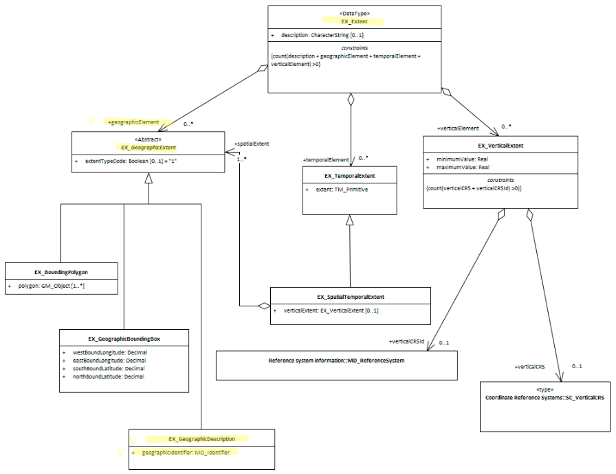
- EX_Extent The class that contains all extent information about the cited resource - vertical, geographical or temporal.
- EX_GeographicExtents is an abstract class and the parent of EX_GeographicDescription
- EX_GeographicBoundingBox - a sibling to this element.
- EX_BoundingPolygon While very useful, particularly in describing irregular areas, this element is not described by the MDWG as a recommended element due to the difficulties that many systems have in implementing it.
- EX_TemporalExtent Contains temporal extent information for the cited resource
- EX_VerticalExtent - captures the vertical range of a resource.
- GeoNames - Provides a free geographical database is available for download free of charge under a creative commons attribution license. It contains over 25 million geographical names and consists of over 11 million unique features whereof 4.8 million populated places and 13 million alternate names. All features are categorized into one out of nine feature classes and further subcategorized into one out of 645 feature codes.
Outstanding Issues
GeoNetwork use of EX_Extent.description The “description” element of EX_Extent offers a freeform way of describing the extent of a resource. GeoNetwork uses it to provide a codelist delimited set of values by which the EX_GeographicBoundingBox elements are populated. It would seem more correct to use EX_GeographicDescription and its MD_Identifier element to this purpose.
Crosswalk considerations
Dublin core / CKAN / data.gov.au {if any}
Mapping geographic extents to CKAN and Dublin core elements, particularly as used by data.gov.au needs discussion
Examples
XML
<mdb:MD_Metadata>
....
  <mdb:identificationInfo>
   <mri:MD_DataIdentification>
   ....
     <mri:extent>
      <gex:EX_Extent>
        <gex:temporalElement>
         <gex:EX_TemporalExtent>
           <gex:extent>
            <gml:TimePeriod gml:id="A1234">
              <gml:beginPosition/>
              <gml:endPosition/>
            </gml:TimePeriod>
           </gex:extent>
         </gex:EX_TemporalExtent>
        </gex:temporalElement>
      </gex:EX_Extent>
     </mri:extent>
     <mri:extent>
      <gex:EX_Extent>
        <gex:geographicElement>
         <gex:EX_GeographicBoundingBox>
           <gex:westBoundLongitude>
            <gco:Decimal>110.70922852</gco:Decimal>
           </gex:westBoundLongitude>
           <gex:eastBoundLongitude>
            <gco:Decimal>157.79663086</gco:Decimal>
           </gex:eastBoundLongitude>
           <gex:southBoundLatitude>
            <gco:Decimal>-39.32048764</gco:Decimal>
           </gex:southBoundLatitude>
           <gex:northBoundLatitude>
            <gco:Decimal>-10.68489957</gco:Decimal>
           </gex:northBoundLatitude>
         </gex:EX_GeographicBoundingBox>
        </gex:geographicElement>
        <gex:geographicElement>
         <gex:EX_GeographicDescription>
           <gex:geographicIdentifier>
            <mcc:MD_Identifier>
              <mcc:code>
               <gco:CharacterString>
               Australia
               </gco:CharacterString>
              </mcc:code>
            </mcc:MD_Identifier>
           </gex:geographicIdentifier>
         </gex:EX_GeographicDescription>
        </gex:geographicElement>
      </gex:EX_Extent>
     </mri:extent>
   ....
   </mri:MD_DataIdentification>
  </mdb:identificationInfo>
....
</mdb:MD_Metadata>
\pagebreak
UML diagrams
Recommended elements highlighted in yellow
\pagebreak