Spatial Reference System ★★★★
In order to be of repeatable use and combined with other resources, geospatial information is most always captured according to a spatial reference system - (SRS). (Also referred to as a Coordinate Reference System - CRS.) Sharing the specifics of the reference systems used allows the resource to be compared and combined with others with precision and accuracy.
| Element Name | referenceSystemInfo |
| Parent | MD_Metadata |
| Class/Type | MD_ReferenceSystem |
| Governance | Common ICSM (for acceptable CRS registries) |
| Domain (for acceptable values within a community of users) | |
| Purpose | Usage, Fitness |
| Audience | machine resource - ⭑ ⭑ ⭑ ⭑ |
| general - ⭑ ⭑ | |
| resource manager - ⭑ ⭑ ⭑ ⭑ | |
| specialist - ⭑ ⭑ ⭑ ⭑ ⭑ | |
| Metadata type | Structural |
| ICSM Level of Agreement | ⭑ ⭑ ⭑ |
Definition
The information about the reference systems that define the system use to describe spatial position descriptions in a resource.
ISO Obligation
- There should be zero or many [0..*] spatialReferenceInfo packages for the cited resource in the MD_Metadata package of class MD_ReferenceSystem in a metadata record for spatial resources.
Discussion
In order to common understand of location in geospatial resource, standardised spatial reference systems are used. A spatial reference helps describe where features are located in the real world. Different spatial reference systems are used for different purposes. (The terms spatial reference and coordinate system used interchangeably although they are slightly different.) People and machines that use spatial resources need to be provided in the metadata the details of the spatial reference systems used by the resource in order to conduct meaningful analysis and to combine this resource with others.
To adequately describe a resource, there may be the need to include multiple SRS in the metadata. Usually, each of these would be of a different type (referenceSystemType).
Dynamic (Earth Centric) Datums Real world coordinates do change over time due to movements of the Earth’s crust. These changes are significant and need be accounted for when combining data from different time periods. For Australia continental drift accounts for up to 70mm per year or 1.8 metres over the past 26 years. When the SRS is Earth centered as is the case with WGS 84, in order to understand position relative to object catured in the same SRS but at a different date, the Coordinate Epoch (time of posisiton information capture) must be recorded. A method of capturing this information within the ISO 19115-1 standard is under development. A best practice way of doing so in the interim is as follows:
- Create an additional Instance of spatialReferenceInfo of referenceSystemType - temporal. The Description should read Coordinate Epoch. The code value should be the year in decimal degrees of at least 2 decimal places for the value of the coordinate reference frame within which the data is captured. For instance, if the data is captured using a GNSS device, the Coordinate Epoch may be the date at which the Coordinates were captured dependent on the methodology used. If the data is digitised from imagery, the Coordinate Epoch would be the same as that of the source imagery. The user must take care to determine the true coordinate system of their source data or method including its coordinate epoch.
Best Practice Recommendations
Therefore - To ensure the usability of your spatial resource, it is important to include the Spatial Reference System used by this resource in its metadata. Doing so will allow the proper use and analysis to occur.
At a minimum the reference system type, the code and the codespace must be captured. In addition the Coordinate Epoch should be captured so changes in coordinate positions due to movements in the earth’s crust can be accounted for. Until ISO 19115-1 support the capture of Coordinate Epoch directly, the creation of a separate instance of MD_Reference system should be created of type temporal with the decimal year to at least to places of the coordinate epoch as code and “Coordinate Epoch - Horizontal” or “Coordinate Epoch - Vertical” as *description.
To date the European Petroleum Survey Group (EPSG) holds the most complete and common register of SRS. It is recommended that this source be used as codespace (and authority?) for SRS information in the metadata.
NOTE - There should be at least two instances of referenceSystemInfo for every resource that contains spatial information referenced to a datum. The first will provide reference to the spatial reference system used by the resource. The second will contain a Coordinate Epoch. This will be of referenceSystemType Temporal with a description of Coordinate Epoch. The value of the code will be the date of the the Coordinate Epoch in Decimal Year to least two places.
Recommended Sub-Classes
- referenceSystemType - (codelist - MD_ReferenceSystemTypeCode) 0 to 1 - to describe the type of system used. This value should be
- referenceSystemIdentifier - (class - MD_Identifier) mandatory - identifier, codespace and authority information for reference system
- code - (type - charStr) mandatory - alphanumeric value identifying an instance in the namespace, e.g. ‘4283’, ‘4326’ . For Coordinate Epoch this code is the date in decimal year up to two decimal places
- codespace - (type - charStr) strongly recommended (except for coordinate epoch) - Identifier or namespace in which the code is valid, e.g. EPSG
- version - (type - charStr) optional - use if needed to distinguish a code
- description - (type - charStr) optional - Common language description of the reference system, e.g. ‘WGS84 - World Geodetic System 1984, used in GPS’, ‘NZTM’. For Coodinate Epoch this value should be “Decimal Year”
- authority - (class - CI_Citation) optional (GA, ABARES - conditional?) - Information about the party responsible for the spatial or temporal reference system used in this cited resource.
- description - Should read
Coordinate Epochwhen referenceSystemInfo instance is describing the Coordinate Epoch. Otherwise this field is optional
Related Codelists
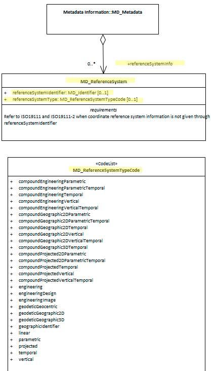
MD_ReferenceSystemTypeCode
There are 28 options to choose from in the reference system type code list (MD_ReferenceSystemTypeCode). Many would never be used by a particular professional. The most common for most geospatial professionals is ‘projected’. The list below sorts these options with the most common on top.
- Common
- projected - coordinate reference system derived from a two-dimensional geodetic coordinate reference system by applying a map projection e.g. easting, northing
- temporal - reference system against which time is measured e.g. time
- vertical - one-dimensional coordinate reference system based on a vertical datum (datum describing the relation of gravity-related heights or depths to the Earth) e.g. [gravity-related] height or depth
- geodeticGeographic2D - geodetic CRS having an ellipsoidal 2D coordinate system e.g. latitude, longitude
- geodeticGeographic3D - geodetic CRS having an ellipsoidal 3D coordinate system e.g. latitude, longitude, ellipsoidal height
- Less common
- geodeticGeocentric - geodetic CRS having a Cartesian 3D coordinate system e.g. [geocentric] X,Y,Z
- geographicIdentifier - spatial reference in the form of a label or code that identifies a location e.g. post code
- linear - reference system that identifies a location by reference to a segment of a linear geographic feature and distance along that segment from a given point e.g. x km along road
- Specialised
- compoundGeographic2DTemporal - compound spatio-temoral coordinate reference system containing a 2 dimensional geographic horizontal coordinate reference system and a temporal reference system e.g. latitude, longitude, time
- compoundGeographic2DVertical - compound coordinate reference system in which one constituent coordinate reference system is a horizontal geodetic coordinate reference system and one is a vertical coordinate reference system e.g. latitude, longitude, [gravity-related] height or depth
- compoundGeographic2DVerticalTemporal - compound spatio-temporal coordinate reference system containing a 2 dimensional geographic horizontal, a vertical, and a temporal coordinate reference system e.g. latitude, longitude, height, time
- compoundGeographic3DTemporal - compound spatio-temporal coordinate reference system containing a 3 dimensional geographic and a temporal coordinate reference system e.g. latitude, longitude, ellipsoidal height, time
- compoundGeographic2DParametric - compound statio-parametric coordinate reference system containing a 2 dimensional geographic horizontal coordinate reference system and a parametric reference system e.g. latitude, longitude, pressure
- compoundGeographic2DParametricTemporal - compound statio-parametric-temporal coordinate reference system containing a 2 dimensional geographic horizontal, a parametric and a temporal coordinate reference system e.g. latitude, longitude, pressure, time
- compoundProjected2DParametric - compound statio-parametric coordinate reference system containing a projected horizontal coordinate reference system and a parametric reference system e.g. easting, northing, density
- compoundProjected2DParametricTemporal - compound statio-parametric-temporal coordinate reference system containing a projected horizontal, a parametric, and a temporal coordinate reference system e.g. easting, northing, density, time
- compoundProjectedTemporal - compound spatio-temporal coordinate reference system containing a projected horizontal and a temporal coordinate reference system e.g. easting, northing, time
- compoundProjectedVertical - compound spatial reference system containing a horizontal projected coordinate reference system and a vertical coordinate reference system e.g. easting, northing, [gravity-related] height or depth
- compoundProjectedVerticalTemporal - compound spatio-temporal coordinate reference system containing a projected horizontal, a vertical, and a temporal coordinate reference system e.g. easting, northing, height, time
- engineering - coordinate reference system based on an engineering datum (datum describing the relationship of a coordinate system to a local reference)e.g. [local] x,y
- engineeringDesign - engineering coordinate reference system in which the base representation of a moving object is specified e.g. [local] x,y
- engineeringImage - coordinate reference system based on an image datum (engineering datum which defines the relationship of a coordinate system to an image)e.g. row, column
- parametric - coordinate reference system based on a parametric datum (datum describing the relationship of a parametric coordinate system to an object) e.g. pressure
- compoundEngineeringParametric - compound spatio-parametric coordinate reference system containing an engineering coordinate reference system and a parametric reference system e.g. [local] x, y, pressure
- compoundEngineeringParametricTemporal - compound spatio-parametric-temporal coordinate reference system containing an engineering, a parametric, and a temporal coordinate reference system e.g. [local] x, y, pressure, time
- compoundEngineeringTemporal - compound spatio-temporal coordinate reference system containing an engineering and a temporal coordinate reference system e.g. [local] x, y, time
- compoundEngineeringVertical - compound spatial reference system containing a horizontal engineering coordinate reference system and a vertical coordinate reference system e.g. [local] x, y, height
- compoundEngineeringVerticalTemporal - compound spatio-temporal coordinate reference system containing an engineering, a vertical, and a temporal coordinate reference system e.g. [local] x, y, height, time
Also Consider
- Spatial representation information (class - MD_SpatialRepresentation) Not discussed by MDWG. Contains detailed information about digital mechanisms used to represent spatial information. Particularly useful for gridded data.
Outstanding Issues
Dynamic (Earth Centric) Datums The latest amendment to ISO 19115-1 includes support for Coordinate Epoch capture as a sibling element to ReferenceSystemIdentifier. This guidance will be updated accordingly following the publication and adoption of these modifications
Authority Authority has been indicated as a conditional field by ABARES and GA. But little guidance exist on the use of this element in this context. Should authority be about the owner of the registry (e.g. EPSG) or the provider of the SRS (LINZ in the case of NZTM)?
MD_ReferenceSystemTypeCode This is a long and confusing list. Should we recommend a shortly one?
Crosswalk considerations
Dublin core / CKAN / data.gov.au
No mapping provided
DCAT
Maps to dct:conformsTo
RIF-CS
Maps to the aggregate element Coverage/Spatial
Examples
XML
<mdb:MD_Metadata>
....
  <mdb:referenceSystemInfo>
      <mrs:MD_ReferenceSystem>
         <mrs:referenceSystemIdentifier>
            <mcc:MD_Identifier>
               <mcc:code>
                  <gco:CharacterString>WGS 1984</gco:CharacterString>
               </mcc:code>
            </mcc:MD_Identifier>
         </mrs:referenceSystemIdentifier>
      </mrs:MD_ReferenceSystem>
  </mdb:referenceSystemInfo>
....
</mdb:MD_Metadata>
UML diagrams
Recommended elements highlighted in yellow
\pagebreak