Vertical Extent ★★★
To quickly determine the general location of features included in an identified resource it is useful that the extent information include any descriptions vertical extents.
| Element Name | verticalElement |
| Parent | MD_Metadata.identificationInfo>MD_Identification.extent |
| Class/Type | EX_VerticalExtent |
| Purpose | Discovery |
| Audience | machine resource - ⭑ ⭑ ⭑ ⭑ |
| general - ⭑ ⭑ ⭑ ⭑ | |
| resource manager - ⭑ ⭑ | |
| specialist - ⭑ ⭑ ⭑ (higher if domain specific time periods are used) | |
| Metadata type | descriptive |
| ICSM Level of Agreement | ⭑ ⭑ ⭑ |
Definition
Provides vertical component of the extent of the resource to aid discovery.
ISO Obligation
- There can be zero to many [0..*] verticalElements packages for the cited resource in the Resource Extent package of class EX_VerticalExtent for a resource cited in a metadata record.
Discussion
Every metadata record describing resources which contain height or depth information should describe the limits of that extent. These extents descriptions should include units of measure and other information so that those searching for resources can be provided with a quick idea of the vertical range of the resource.
The use of multiple vertical extents is useful for describing more complicated resources.
Best Practice Recommendations
Therefore - it is strongly recommended that to support the discovery of resources, every metadata record contains, as needed vertical extent description of the resource area of interest. Capture the units of measure and the datum used.
The MDWG recommends, when the heights and depths of a resource are important to the resource, populating as many instances of Vertical Extent packages as needed to give a common understanding of the depth and elevation coverage of the cited resource.
Recommended Sub-Elements
- minimumValue - (type - Real) The minimum vertical extent to which the resource is designed to be used
- maximumValue - (type - Real) The maximum vertical extent to which the resource is designed to be used
- verticalCRSId - (class - SC_VerticalCRS ) Identifies the vertical coordinate reference system used for the minimum and maximum values
Also Consider
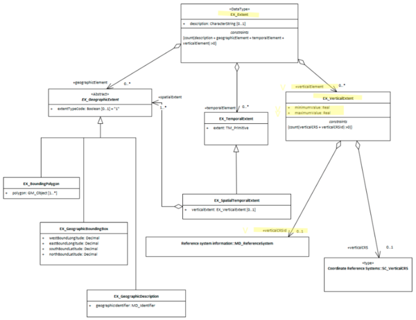
- EX_Extent The class that contains all extent information about the cited resource - vertical, geographical or temporal.
- EX_GeographicExtents is an abstract class that can be express three ways:
- EX_GeographicBoundingBox - at least one of these should be present for resources that describe geographic resources
- EX_GeographicDescription - One of these should be present for resources that describe geographic resources
- EX_BoundingPolygon While very useful, particularly in describing irregular areas, this element is not described by the MDWG as a recommended element due to the difficult that many systems have in implementing it.
- EX_TemporalExtent Contains temporal extent information for the cited resource
Outstanding Issues
verticalCRS The vertical CRS can be captured here or under the SpatialRefenceSystem package. We need to decide when to recommend capturing it here. As other extent parameters do not include the CRS, I would make a recommendation that we treat vertical the same and capture this info in the SRS section. Note BC 21-9: GN in the 19115-3 plugin captures the extent info as the old RS_Identifier instead of MD_Identifier
Units of measure These are not specified. I would suggest that we use metres relative to sea level WGS 84 as the universal units for vertical extents. As with the mandate of WGS 84 for the projection for bounding box extents, it is important to have as a close to a universally common reference frame as we can get to compare disparate resources.
Datum Issues What is “zero” is an open question. There may be little common between domains. In 3D cadastre, the level above ground may be the measure. There also is no agreement between land vertical datums and those for the sea.
Crosswalk considerations
Dublin core / CKAN / data.gov.au
Mapping to CKAN and Dublin core elements, particularly as used by data.gov.au needs discussion
DCAT
Maps to dct.spatial
RIF-CS
Maps to Coverage/Spatial
Examples
XML
<mdb:MD_Metadata>
....
  <mdb:identificationInfo>
   <mri:MD_DataIdentification>
     ....
     <mri:extent>
      <gex:EX_Extent>
        <gex:verticalElement>
         <gex:EX_VerticalExtent>
           <gex:minimumValue>
            <gco:Real>-1000</gco:Real>
           </gex:minimumValue>
           <gex:maximumValue>
            <gco:Real>1000</gco:Real>
           </gex:maximumValue>
           <gex:verticalCRSId>
            <mrs:MD_ReferenceSystem>
              <gmd:referenceSystemInfo xmlns:gmd="http://www.isotc211.org/2005/gmd">
               <gmd:MD_ReferenceSystem>
                 <gmd:referenceSystemIdentifier>
                  <gmd:RS_Identifier>
                    <gmd:code>
                     <gco:CharacterString
                     xmlns:gco="http://www.isotc211.org/2005/gco">
                     WGS 84 (EPSG:4326)</gco:CharacterString>
                    </gmd:code>
                    <gmd:codeSpace>
                     <gco:CharacterString
                     xmlns:gco="http://www.isotc211.org/2005/gco">
                     EPSG
                     </gco:CharacterString>
                    </gmd:codeSpace>
                    <gmd:version>
                     <gco:CharacterString
                     xmlns:gco="http://www.isotc211.org/2005/gco">
                     8.6
                     </gco:CharacterString>
                    </gmd:version>
                  </gmd:RS_Identifier>
                 </gmd:referenceSystemIdentifier>
               </gmd:MD_ReferenceSystem>
              </gmd:referenceSystemInfo>
            </mrs:MD_ReferenceSystem>
           </gex:verticalCRSId>
         </gex:EX_VerticalExtent>
        </gex:verticalElement>
      </gex:EX_Extent>
     </mri:extent>
   ....
   </mri:MD_DataIdentification>
  </mdb:identificationInfo>
....
</mdb:MD_Metadata>
\pagebreak
UML diagrams
Recommended elements highlighted in yellow
\pagebreak