Extent Bounding Box ★★★★
*To quickly determine the general location of spatial features included in a cited resource it is useful that the extent information includes a minimal set of coordinate values that form a bounding box containing all the features of the resource.**
| Element Name | geographicElement |
| Parent | MD_Metadata.identificationInfo>MD_Identificationextent >EX_Extent.geographicElement> |
| Class/Type | EX_GeographicBoundingBox |
| Governance | Common ICSM, Domain |
| Purpose | Discovery |
| Audience | machine resource - ⭑ ⭑ ⭑ ⭑ |
| general - ⭑ ⭑ ⭑ ⭑ | |
| resource manager - ⭑ ⭑ | |
| specialist - ⭑ ⭑ ⭑ | |
| Metadata type | descriptive |
| ICSM Level of Agreement | ⭑ ⭑ ⭑ ⭑ |
Definition
A minimal set of geographic coordinates describing the geographic position of the resource. This is only an approximate reference so specifying the coordinate reference system is unnecessary and need only be provided with a precision of up to two decimal places
ISO Obligation
- A metadata record may have zero to many [0..*] geographicIdentifier elements for the cited resource in the GeographicExtent package of class EX_GeographicBoundingBox that described the geographic extent of a cited resource.
Discussion
Every metadata record describing geographic resources should contain a bounding box description that covers the location which describes the area of interest of the resource. Those searching for resources can be provided with a quick visual of the usable location of the resource. Catalogue software can use these boxes to do overlay analyses and narrow searches to particular areas of interest. To ensure ease of use with metadata from other sources that may contain data in any number of projections, these bounding box needs to be expressed in a common WGS 84 projection.
Because of the simple mathematics involved in calculating overlap with two coordinate pairs, bounding box descriptions provide a lightweight way that those without GIS tools can tell if the resource overlaps with another.
The use of multiple bounding boxes is recommended for more complicated geometries, including exclusion areas.
Best Practice Recommendations
Therefore - it is strongly recommended that to support the discovery of resources, every metadata record that describes a geographic resource contains at a minimum one bounding box description of the resource area of interest. To ensure commonality with other catalogued data, the coordinates of such need be captured in WGS 84. If there be any exclusion areas, the use of the boolean extentTypeCode (set to “0”) is recommended.
The MDWG recommends populating as many instances of Geographical Extent packages as needed to give a common understanding of the spatial coverage of the cited resource.
Recommended Sub Elements
Use extentTypeCode (Boolean) [0..1] with a value of “0” to indicate exclusions All four following subelements must be included in a bounding box description
- westBoundLongitude - (type - Decimal) western-most coordinate of the limit of the resource extent, expressed in longitude in decimal degrees (positive east - WGS 84)
- eastBoundLongitude - (type - Decimal) eastern-most coordinate of the limit of the resource extent, expressed in longitude in decimal degrees (positive east - WGS 84)
- southBoundLatitude - (type - Decimal) southern-most coordinate of the limit of the resource extent, expressed in latitude in decimal degrees (positive north - WGS 84)
- eastBoundLongitude - (type - Decimal) northern-most, coordinate of the limit of the resource extent expressed in latitude in decimal degrees (positive north - WGS 84)
Also Consider
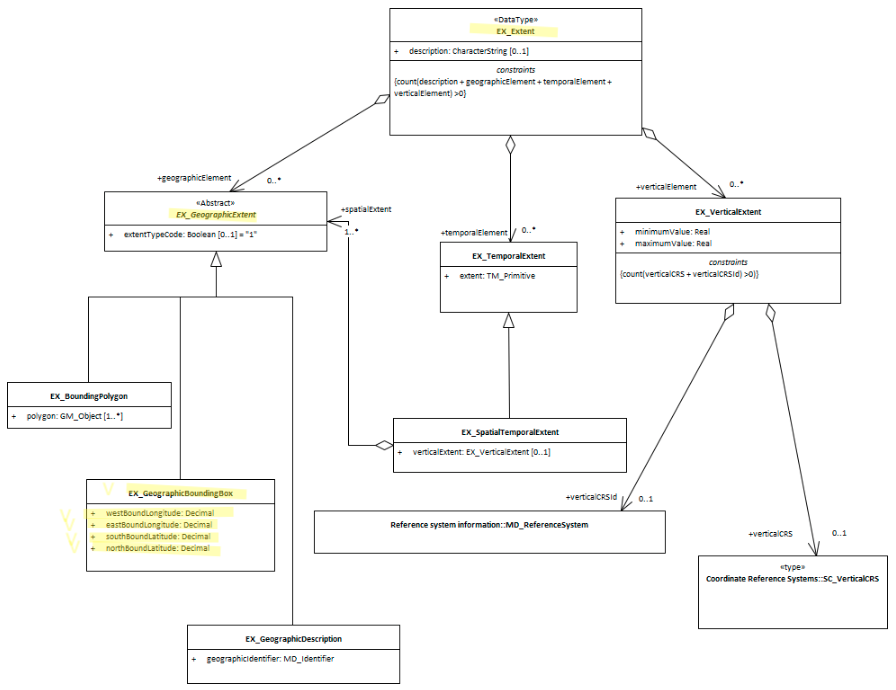
- EX_Extent The class that contains all extent information about the cited resource - vertical, geographical or temporal.
- EX_GeographicExtents is an abstract class and the parent of EX_GeographicBoundingBox
- EX_GeographicDescription - a sibling to this element.
- EX_BoundingPolygon While very useful, particularly in describing irregular areas, this element is not described by the MDWG as a recommended element due to the difficulties that many systems have in implementing it.
- EX_TemporalExtent Contains temporal extent information for the cited resource
- EX_VerticalExtent - captures the vertical range of a resource.
Outstanding Issues
Projections Geospatial data may be held and maintained by an organisation in any number of projections. Capturing the bounding box in common WGS 84 coordinates may require reprojection of coordinates. Workflows and tools need to be available to the metadata authors to simplify this task and reduce transcription errors.
180 degree problem To capture a bounding box that describes the area of the country of New Zealand, one must draw across 180 degrees Longitude. This creates an issue with most software descriptions of bounding boxes and results in a bounding box that circles the world and excludes New Zealand. One common solution is to split into two such bounding boxes at +/-180 degree latitude.
Crosswalk considerations
Dublin core / CKAN / data.gov.au
Maps to geospatial coverage
DCAT
Maps to dct.spatial
RIF-CS
Maps to the aggregate element Coverage/Spatial
Examples
XML
<mdb:MD_Metadata>
....
   <mdb:identificationInfo>
    <mri:MD_DataIdentification>
     ....
       <gex:EX_Extent>
        <gex:geographicElement>
         <gex:EX_GeographicBoundingBox>
           <gex:westBoundLongitude>
            <gco:Decimal>110.70922852</gco:Decimal>
           </gex:westBoundLongitude>
           <gex:eastBoundLongitude>
            <gco:Decimal>157.79663086</gco:Decimal>
           </gex:eastBoundLongitude>
           <gex:southBoundLatitude>
            <gco:Decimal>-39.32048764</gco:Decimal>
           </gex:southBoundLatitude>
           <gex:northBoundLatitude>
            <gco:Decimal>-10.68489957</gco:Decimal>
           </gex:northBoundLatitude>
         </gex:EX_GeographicBoundingBox>
        </gex:geographicElement>
       </gex:EX_Extent>
      ....
    </mri:MD_DataIdentification>
   </mdb:identificationInfo>
  ....
</mdb:MD_Metadata>
\pagebreak
UML diagrams
Recommended elements highlighted in yellow
\pagebreak