|
External identifier of this document: https://linked.data.gov.au/def/csdm/profiles/nz |
NZ Profile for ICSM Cadastral Survey Data Exchange Model.
Vocabularies
A summary of properties that have vocabularies as target values.
| Property | Classes | Vocabularies |
|---|---|---|
|
Administration Unit |
||
|
horizontal CRS |
||
|
https://linked.data.gov.au/def/csdm/surveyfeatures/condition |
||
|
monument condition |
||
|
Monument physical form |
||
|
https://linked.data.gov.au/def/csdm/surveyfeatures/parcelType |
||
|
ns4:parcelType |
||
|
https://linked.data.gov.au/def/csdm/surveyfeatures/angleType |
||
|
ns5:angleType |
||
|
https://linked.data.gov.au/def/csdm/surveyfeatures/distanceType |
||
|
ns5:distanceType |
||
|
parcel purpose |
||
|
parcel state |
||
|
purpose |
||
|
https://linked.data.gov.au/def/csdm/surveyfeatures/vectorPurpose |
||
|
purpose for a survey vector |
||
|
state |
||
|
survey type |
||
|
used procedure |
||
Modules and Class Hierarchy
- Survey Plan Container Model
- Cadastral Parcel
- Survey Features Model
-
Survey Observations Model
- BIM/IFC design model reference
- Computation
- Design Model of Occupation
- Instrument Setup
- Occupation As Feature
- Occupation Model Vertex
- Occupation Observations
- Offset Measurement
- Position
- Qualified Position
- Qualified Vector
- Side Shot
- Survey Network
- Survey Observation
- Survey Traversal
- Traverse
- Vector Determination
- Vector Determination Method
- Vector Observations
- Survey Provenance Model
- Common implementation patterns not directly supported by other standards
- ns1:geometryprim
Module: Survey Plan Container Model
Import closure for 3D model packages and aggregation containers for exchange objects.
Classes
Cadastral Survey Dataset
IRI: https://linked.data.gov.au/def/csdm/container/CSD
The set of cadastral survey data necessary to integrate a cadastral survey into, or transfer survey observations from, a cadastral database. A CSD identifier may be used to reference a previous survey. This exists without adequate definition in both LandInfra and landXML
|
Scope Note
|
Cadastral Survey Datasets may reference data from previous surveys, the extracted subset for each relevant previous survey is contained within a separate CSD object referenced by the CSD being submitted. Implementations will determine how these make be packaged, conceptually referenced CSDs are seen as a property of any given CSD |
Is defined by Survey Plan Container Model
Subclass of
Properties
| Property | Description | Constraints | ||
|---|---|---|---|---|
|
Administration Unit Sourced from class:
|
Qualified reference to Administration Unit identifiers. |
Values expected to be from the following vocabulary: with an expected class type of: |
||
|
AdminUnit Value Sourced from class:
|
Qualified reference to Administration Unit identifiers. |
Expected class type Local Administrative Unit Cardinality: [1..*] |
||
|
AdminUnit Type Sourced from class:
|
Qualified reference to Administration Unit identifiers. |
Expected class type Localised Administrative Unit Type Cardinality: [1..*] |
||
|
Administration Unit / ns1:hasTarget Sourced from class:
|
Qualified reference to Administration Unit identifiers. |
Expected class type Local Administrative Unit Cardinality: [1..*] |
||
|
Administration Unit / prof:hasRole Sourced from class:
|
Qualified reference to Administration Unit identifiers. |
Expected class type Localised Administrative Unit Type Cardinality: [1..*] |
||
|
Administration Unit Sourced from class:
|
Qualified reference to Administration Unit identifiers. |
Values expected to be from the following vocabulary: with an expected class type of: |
||
|
occupation observations Sourced from class:
|
Optional observations about the nature of occupations, allowing arbitrary additional details to be recorded. |
Expected class type sosa:ObservationCollection |
||
|
Occupation features Sourced from class:
|
A set of feature descriptions for occupation evidence. May be referenced by occupation observations for extended detail, or presence of such features inferred by presence of observations. This property supports use of multipe collections of features sourced from other systems. |
Expected class type geo:Feature |
||
|
parcels Sourced from class:
|
the set of Parcels defined or re-surveyed by this survey. These reference vectors which in turn reference the points coordinate geometry of the survey, using topological relationships to these points via the "id" property. |
Expected class type Feature Collection |
||
|
survey provenance Sourced from class:
|
A bundle of survey provenance information must be present. |
Expected class type prov:Bundle Cardinality: [1] |
||
|
referenced CSD Sourced from class:
|
A CSD containing referenced survey features and observations |
Expected class type Cadastral Survey Dataset |
||
|
points Sourced from class:
|
the set of survey points defined or re-surveyed by this survey. These contain all the coordinate geometry of the survey, other features are defined using topological relationships to these points by the "id" property. |
Expected class type Feature Collection |
||
|
Survey Purpose valid Sourced from class:
|
the purpose of a survey |
Expected class type Survey Purpose Cardinality: [1..*] |
||
|
Survey Purpose valid Sourced from class:
|
the purpose of a survey |
Expected class type Survey Purpose Cardinality: [1..*] |
||
|
Vector Observations / made by sensor Sourced from class:
|
Relation between an Observation and the Sensor which made the Observation. |
Cardinality: [1..*] |
||
|
vector observations Sourced from class:
|
The set of observations of surveyed vectors between SurveyPoints |
Expected class type sosa:ObservationCollection Cardinality: [0..1] |
||
|
bearing rotation Sourced from class:
|
Bearing Rotation to adopt when referencing vectors in this CSD. |
|||
|
Description Sourced from class:
|
Description of Survey. Note this should not repeat information in provenance, appellation or other machine readable forms and be limited to additional information. |
|||
|
(horizontalCRS) |
||||
|
horizontal CRS Sourced from class:
|
The CRS to assume for all horizontal coordinates in scope of this object. |
Values expected to be from the following vocabulary: with an expected class type of: |
||
|
horizontal CRS Sourced from class:
|
The CRS to assume for all horizontal coordinates in scope of this object. |
Expected class type Allowed CRS |
||
|
horizontalCRS Sourced from class:
|
Horizontal CRS - in form to be defined by encoding requirements. |
Cardinality: [1] |
||
|
Adopted Observations Sourced from class:
|
Adopted observations (collection) |
Expected class type sosa:ObservationCollection |
||
|
(ns2:annotations / prof:hasRole) |
||||
|
Annotation Document Role Sourced from class:
|
Expected class type Localised Annotation Role |
|||
|
ns2:annotations / prof:hasRole Sourced from class:
|
Expected class type Localised Annotation Role |
|||
|
(ns2:supportingDocuments / prof:hasRole) |
||||
|
Supporting Document Role Sourced from class:
|
Expected class type Localised Document Type |
|||
|
ns2:supportingDocuments / prof:hasRole Sourced from class:
|
Expected class type Localised Document Type |
|||
|
(survey type) |
||||
|
Survey Type valid Sourced from class:
|
Expected class type Localised Survey Type Cardinality: [1..*] |
|||
|
Survey Type valid Sourced from class:
|
Expected class type Localised Survey Type Cardinality: [1..*] |
|||
|
survey type Sourced from class:
|
Values expected to be from the following vocabulary: with an expected class type of: |
|||
|
(vertical datum) |
||||
|
verticalDatum Sourced from class:
|
The verticalDatum to assume for all height values in scope of this object. |
Expected class type Allowed CRS |
||
|
vertical datum Sourced from class:
|
Vertical Datum - in form to be defined by encoding requirements. |
Cardinality: [0..1] |
||
Examples
examples1:SurveyExample
  a container:CSD ;
  rdfs:label "Example Cadastral Survey Dataset" ;
  prov:wasGeneratedBy surveyobs_examples:surveyActivity1 ;
  container:calculatedObservations surveyobs_examples:calculated_observations ;
  container:occupationFeatures surveyobs_examples:fence1 ;
  container:referencedCSD surveyobs_examples:csd2 ;
  container:vectorObservations surveyobs_examples:vector_observations ;
.
Survey Type
IRI: https://linked.data.gov.au/def/csdm/surveyprov/SurveyType
A codelist of survey types relevant to a particular jurisdiction. i.e. whether the survey was part-compiled, compiled, computed or surveyed.
Is defined by Survey Plan Container Model
Subclass of
Object Properties
Observations on Occupation Features
IRI: https://linked.data.gov.au/def/csdm/container/occupationObservations
the set of observations about the nature of occupation present for survey features. Note that the relative positions of occupation features may be present as vector observations.
Occupation Features
IRI: https://linked.data.gov.au/def/csdm/container/occupationFeatures
Occupation Features referenced in occupation observations or by specific Observation Marks
Parcels
IRI: https://linked.data.gov.au/def/csdm/container/parcels
the set of Parcels defined or re-surveyed by this survey. These reference vectors which in turn reference the points coordinate geometry of the survey, using topological relationships to these points via the "id" property.
Provenance
IRI: https://linked.data.gov.au/def/csdm/container/surveyProvenance
The set of activities, actors and related information objects describing the provenance of an object
Survey Points
IRI: https://linked.data.gov.au/def/csdm/container/points
the set of survey points defined or re-surveyed by this survey. These contain all the coordinate geometry of the survey, other features are defined using topological relationships to these points by the "id" property.
Vector Observations
IRI: https://linked.data.gov.au/def/csdm/container/vectorObservations
the set of observed vectors defined or re-surveyed by this survey - adopted vectors will be present in the context of the original CSD they are adopted from to preserve metadata.
Module: Cadastral Parcel
A model for cadastral parcels
Classes
Estate
IRI: https://linked.data.gov.au/def/csdm/parcels/Estate
A set of real property rights that can be held by a legal entity.
|
Editorial Note
|
An estate is not modelled explicitly - it is simply a reference to an external system - for example a persistent IRI or local system identifier. Implementing profiles may define addtional metadata for such references if needed. |
Is defined by Cadastral Parcel
Subclass of
Estate Parcel
IRI: https://linked.data.gov.au/def/csdm/parcels/EstateParcel
The spatial extent of an Estate. It may consist of one or more cadastral parcels.
Is defined by Cadastral Parcel
Subclass of
Properties
| Property | Description | Constraints | ||
|---|---|---|---|---|
|
interest / ns4:interestLink Sourced from class:
|
Cardinality: [1..*] |
|||
|
interest Sourced from class:
|
Cardinality: [1..*] |
|||
|
parcel Sourced from class:
|
||||
|
boundedBy Sourced from class:
|
A Feature whose geometry forms part of the boundary of two other features bounded by a higher dimensional geometry. |
|||
|
geo:ehOverlap Sourced from class:
|
Expected class type 3D Spatial Unit |
|||
|
hasGeometry Sourced from class:
|
Constrain geometry to a form that supports calculation of interior and surface domains. |
Expected class type Abstract Solid Geometry |
||
|
hasGeometryPart Sourced from class:
|
A component geometry part potentially containing references to reusable used in the main geometry representation |
Expected class type geo:Geometry |
||
Interest In Land
IRI: https://linked.data.gov.au/def/csdm/parcels/LandInterest
An Interest In Land is ownership or security towards real property.
|
Editorial Note
|
This is from LandInfra - Easement is just one example here but it may be worth making explicit as it is the touch point with the LandInfra scope. |
Is defined by Cadastral Parcel
Superclass of
Appellation
IRI: https://linked.data.gov.au/def/csdm/parcels/Appellation
The legal description for a specific piece of land.
Is defined by Cadastral Parcel
Subclass of
Properties
| Property | Description | Constraints | ||
|---|---|---|---|---|
|
dcterms:hasPart Sourced from class:
|
A typed part of a name, to be formatted into a final form according to localised business rules. |
Expected class type Name Part Cardinality: [1..*] |
||
|
rdfs:label Sourced from class:
|
Default simple string value |
Cardinality: [0..1] |
||
Cadastral Parcel
IRI: https://linked.data.gov.au/def/csdm/parcels/Parcel
A single or multi area, or solid, above, or below the surface of the earth as specified through legislated process. The extent of a cadastral parcel can be described by a surface or solid and topological relationships with other parcels.
Is defined by Cadastral Parcel
Subclass of
Superclass of
Properties
| Property | Description | Constraints | ||
|---|---|---|---|---|
|
appellation Sourced from class:
|
The legal description for a specific piece of land. |
Expected class type Appellation Cardinality: [1] |
||
|
interest / ns4:interestLink Sourced from class:
|
Cardinality: [1..*] |
|||
|
interest Sourced from class:
|
Expected class type Interest In Land |
|||
|
Parcel Type Sourced from class:
|
Cardinality: [1..*] |
|||
|
Parcel Type Sourced from class:
|
Cardinality: [1] |
|||
|
parcel quality Sourced from class:
|
Expected class type Quality Classification for Parcel Cardinality: [0..1] |
|||
|
parcel type Sourced from class:
|
Expected class type Parcel Type Cardinality: [1] |
|||
|
surfaceArea Sourced from class:
|
The surface area of the parcel (in the units defined by the given implementation profile of this standard). |
Cardinality: [0..1] |
||
|
terrain intersection Sourced from class:
|
Terrain (ground level) intersection curve of a 3D parcel. |
Expected class type ns1:LinearRing Cardinality: [0..1] |
||
|
boundedBy Sourced from class:
|
A Feature whose geometry forms part of the boundary of two other features bounded by a higher dimensional geometry. |
|||
|
geo:ehOverlap Sourced from class:
|
Expected class type 3D Spatial Unit |
|||
|
hasGeometry Sourced from class:
|
Constrain geometry to a form that supports calculation of interior and surface domains. |
Expected class type Abstract Solid Geometry |
||
|
hasGeometryPart Sourced from class:
|
A component geometry part potentially containing references to reusable used in the main geometry representation |
Expected class type geo:Geometry |
||
Parcel Aggregate
IRI: https://linked.data.gov.au/def/csdm/parcels/ParcelAggregate
A parcel aggregate is a collection of parcels whose collective extent may be described as a spatial unit.
|
Editorial Note
|
This superclass supports alignment with the LandInfra concept of a LandPropertyUnit without assuming that this is the only requirement to aggregate parcels. |
Is defined by Cadastral Parcel
Subclass of
Superclass of
Properties
| Property | Description | Constraints | ||
|---|---|---|---|---|
|
boundedBy Sourced from class:
|
A Feature whose geometry forms part of the boundary of two other features bounded by a higher dimensional geometry. |
|||
|
geo:ehOverlap Sourced from class:
|
Expected class type 3D Spatial Unit |
|||
|
hasGeometry Sourced from class:
|
Constrain geometry to a form that supports calculation of interior and surface domains. |
Expected class type Abstract Solid Geometry |
||
|
hasGeometryPart Sourced from class:
|
A component geometry part potentially containing references to reusable used in the main geometry representation |
Expected class type geo:Geometry |
||
Parcel Purpose
IRI: https://linked.data.gov.au/def/csdm/parcels/ParcelPurpose
Purpose of parcel.
Is defined by Cadastral Parcel
Subclass of
Primary Cadastral Parcel
IRI: https://linked.data.gov.au/def/csdm/parcels/PrimaryParcel
A parcel that may not overlap with other parcels of the same type - they represent exclusive rights. Different types of primary parcels may be nested within a given type provided no nested parcles are of this type.
Is defined by Cadastral Parcel
Subclass of
Properties
| Property | Description | Constraints | ||
|---|---|---|---|---|
|
appellation Sourced from class:
|
The legal description for a specific piece of land. |
Expected class type Appellation Cardinality: [1] |
||
|
interest / ns4:interestLink Sourced from class:
|
Cardinality: [1..*] |
|||
|
interest Sourced from class:
|
Expected class type Interest In Land |
|||
|
Parcel Type Sourced from class:
|
Cardinality: [1..*] |
|||
|
Parcel Type Sourced from class:
|
Cardinality: [1] |
|||
|
parcel quality Sourced from class:
|
Expected class type Quality Classification for Parcel Cardinality: [0..1] |
|||
|
parcel type Sourced from class:
|
Expected class type Parcel Type Cardinality: [1] |
|||
|
surfaceArea Sourced from class:
|
The surface area of the parcel (in the units defined by the given implementation profile of this standard). |
Cardinality: [0..1] |
||
|
terrain intersection Sourced from class:
|
Terrain (ground level) intersection curve of a 3D parcel. |
Expected class type ns1:LinearRing Cardinality: [0..1] |
||
|
boundedBy Sourced from class:
|
A Feature whose geometry forms part of the boundary of two other features bounded by a higher dimensional geometry. |
|||
|
geo:ehOverlap Sourced from class:
|
Expected class type 3D Spatial Unit |
|||
|
hasGeometry Sourced from class:
|
Constrain geometry to a form that supports calculation of interior and surface domains. |
Expected class type Abstract Solid Geometry |
||
|
hasGeometryPart Sourced from class:
|
A component geometry part potentially containing references to reusable used in the main geometry representation |
Expected class type geo:Geometry |
||
Secondary Cadastral Parcel
IRI: https://linked.data.gov.au/def/csdm/parcels/SecondaryParcel
A parcel representing the extent of a non-exclusive right. Secondary parcels may overlap both primary parcels and other secondary parcels.
Is defined by Cadastral Parcel
Subclass of
Properties
| Property | Description | Constraints | ||
|---|---|---|---|---|
|
geo:ehOverlap Sourced from class:
|
Allow a secondary parcel to overlap any other type of parcel. |
Expected class type Cadastral Parcel |
||
|
geo:ehOverlap Sourced from class:
|
Expected class type 3D Spatial Unit |
|||
|
appellation Sourced from class:
|
The legal description for a specific piece of land. |
Expected class type Appellation Cardinality: [1] |
||
|
interest / ns4:interestLink Sourced from class:
|
Cardinality: [1..*] |
|||
|
interest Sourced from class:
|
Expected class type Interest In Land |
|||
|
Parcel Type Sourced from class:
|
Cardinality: [1..*] |
|||
|
Parcel Type Sourced from class:
|
Cardinality: [1] |
|||
|
parcel quality Sourced from class:
|
Expected class type Quality Classification for Parcel Cardinality: [0..1] |
|||
|
parcel type Sourced from class:
|
Expected class type Parcel Type Cardinality: [1] |
|||
|
surfaceArea Sourced from class:
|
The surface area of the parcel (in the units defined by the given implementation profile of this standard). |
Cardinality: [0..1] |
||
|
terrain intersection Sourced from class:
|
Terrain (ground level) intersection curve of a 3D parcel. |
Expected class type ns1:LinearRing Cardinality: [0..1] |
||
|
boundedBy Sourced from class:
|
A Feature whose geometry forms part of the boundary of two other features bounded by a higher dimensional geometry. |
|||
|
hasGeometry Sourced from class:
|
Constrain geometry to a form that supports calculation of interior and surface domains. |
Expected class type Abstract Solid Geometry |
||
|
hasGeometryPart Sourced from class:
|
A component geometry part potentially containing references to reusable used in the main geometry representation |
Expected class type geo:Geometry |
||
Datatype Properties
Parcel Area
IRI: https://linked.data.gov.au/def/csdm/parcels/area
Parcel Area in units appropriate to CRS definition.
Z Max Value
IRI: https://linked.data.gov.au/def/csdm/parcels/zmax
Upper extent indicator value
|
Scope Note
|
Exact interpretation is implementation and context dependent |
Z Min Value
IRI: https://linked.data.gov.au/def/csdm/parcels/zmin
Lower extent indicator value
|
Scope Note
|
Exact interpretation is implementation and context dependent |
surfaceArea
IRI: https://linked.data.gov.au/def/csdm/parcels/surfaceArea
The surface area of the parcel (in the units defined by the given implementation profile of this standard).
unit volume
IRI: https://linked.data.gov.au/def/csdm/parcels/unitVolume
The reported volume of a 3D spatial unit (in the units defined by the given implementation profile of this standard).
Object Properties
appellation
IRI: https://linked.data.gov.au/def/csdm/parcels/appellation
The legal description for a specific piece of land.
Sub property of:
parcel quality
IRI: https://linked.data.gov.au/def/csdm/parcels/qualityClass
parcelState
IRI: https://linked.data.gov.au/def/csdm/parcels/parcelState
surface
IRI: https://linked.data.gov.au/def/csdm/parcels/surface
Terrain (ground level) of a parcel.
Sub property of:
terrain intersection
IRI: https://linked.data.gov.au/def/csdm/parcels/terrainIntersectionCurve
Terrain (ground level) intersection curve of a 3D parcel.
Sub property of:
Module: Survey Features Model
Feature Types defined by Cadastral Surveys
Classes
Adopted Vector
IRI: https://linked.data.gov.au/def/csdm/surveyfeatures/AdoptedVector
A vector included in a CSD that has previously been observed and included in an existing CSD or Survey Plan.
Is defined by Survey Features Model
Subclass of
Properties
| Property | Description | Constraints | ||
|---|---|---|---|---|
|
Distance Sourced from class:
|
The line of sight distance between the instrument and target point |
Expected class type Distance Measurement |
||
|
from Sourced from class:
|
Start point for a survey line |
Expected class type Survey Point Cardinality: [1] |
||
|
horizontal angle Sourced from class:
|
The horizontal angle of the target point relative to the setup bearing |
Expected class type Angle Measurement |
||
|
purpose for a survey vector Sourced from class:
|
Purpose of vector, using relevant codelist |
Values expected to be from the following vocabulary: with an expected class type of: |
||
|
purpose for a survey vector Sourced from class:
|
Purpose of vector, using relevant codelist |
Cardinality: [1] |
||
|
target Sourced from class:
|
Target (end) point for a survey line |
Expected class type Survey Mark Cardinality: [1] |
||
|
vertical angle Sourced from class:
|
The horizontal angle of the target point relative to the setup bearing |
Expected class type Angle Measurement |
||
|
hasGeometry Sourced from class:
|
hasGeometry property inherited from geo:Feature |
Expected class type geo:Geometry |
||
Boundary Mark
IRI: https://linked.data.gov.au/def/csdm/surveyfeatures/BoundaryMark
Means a location that defines a boundary corner or boundary alignment. The location will be physically marked unless the location is obstructed by a structure that can not be marked. A boundary mark MAY be a Geodetic Reference Mark.
Is defined by Survey Features Model
Subclass of
Properties
| Property | Description | Constraints | ||
|---|---|---|---|---|
|
Monument physical form Sourced from class:
|
Physical form of monument using code list |
Values expected to be from the following vocabulary: with an expected class type of: |
||
|
Monument physical form Sourced from class:
|
Physical form of monument using code list |
Expected class type Monument Form Cardinality: [1..*] |
||
|
Name / dcterms:hasPart / ns2:namePartType Sourced from class:
|
A name composed of components according to localised implementation requirements. |
|||
|
Name / rdfs:label Sourced from class:
|
Test labelled parts present in compound label if present |
Name parts must exist in label if present |
||
|
Name / dcterms:hasPart / ns2:namePartType Sourced from class:
|
A name composed of components according to localised implementation requirements. |
|||
|
Name / dcterms:hasPart / ns2:namePartType Sourced from class:
|
A name composed of components according to localised implementation requirements. |
|||
|
Name / dcterms:hasPart / ns2:namePartType Sourced from class:
|
A name composed of components according to localised implementation requirements. |
|||
|
Name / rdfs:label Sourced from class:
|
Test labelled parts present in compound label if present |
Name parts must exist in label if present |
||
|
name Sourced from class:
|
A name composed of components according to localised implementation requirements. |
Expected class type CompoundName Cardinality: [1] |
||
|
Quality Class Sourced from class:
|
Expected class type ns3:PointQualityClass |
|||
|
(purpose) |
||||
|
purpose Sourced from class:
|
Purpose of an entity using relevant codelist |
Values expected to be from the following vocabulary: with an expected class type of: |
||
|
purpose Sourced from class:
|
Purpose of an entity using relevant codelist |
Expected class type Survey Point Purpose |
||
|
purpose Sourced from class:
|
Purpose of an entity using relevant codelist |
Values expected to be from the following vocabulary: with an expected class type of: |
||
|
purpose Sourced from class:
|
Purpose of an entity using relevant codelist |
Values expected to be from the following vocabulary: with an expected class type of: |
||
|
purpose Sourced from class:
|
Purpose of an entity using relevant codelist |
Values expected to be from the following vocabulary: with an expected class type of: |
||
|
purpose Sourced from class:
|
Purpose of an entity using relevant codelist |
Expected class type Survey Point Purpose Cardinality: [1..*] |
||
|
monumented by / monument condition Sourced from class:
|
Expected class type Monument Condition |
|||
|
monumented by / Monument physical form Sourced from class:
|
Physical form of monument using code list |
Expected class type Monument Form |
||
|
monumented by / state Sourced from class:
|
State of survey point |
Expected class type Survey Point State |
||
|
monumentedBy Sourced from class:
|
Reference to physical monument description |
Expected class type Monument Cardinality: [1] |
||
|
(hasGeometry) |
||||
|
geo:hasGeometry Sourced from class:
|
Expected class type geo:Point Cardinality: [0..1] |
|||
|
hasGeometry Sourced from class:
|
hasGeometry property inherited from geo:Feature |
Expected class type geo:Geometry |
||
|
provenance Sourced from class:
|
Survey point provenance |
Expected class type Survey Point Provenance |
||
Cadastral Feature
IRI: https://linked.data.gov.au/def/csdm/surveyfeatures/CadastralFeature
This is an abstract feature to identify elements of the Cadastral Survey Conceptual Model
Is defined by Survey Features Model
Subclass of
Superclass of
Properties
| Property | Description | Constraints | ||
|---|---|---|---|---|
|
hasGeometry Sourced from class:
|
hasGeometry property inherited from geo:Feature |
Expected class type geo:Geometry |
||
Cadastral Mark
IRI: https://linked.data.gov.au/def/csdm/surveyfeatures/CadastralMark
Any survey mark placed or observed as part of a cadastral survey that is not a boundary mark or a geodetic reference mark
Is defined by Survey Features Model
Subclass of
Properties
| Property | Description | Constraints | ||
|---|---|---|---|---|
|
Name / dcterms:hasPart / ns2:namePartType Sourced from class:
|
A name composed of components according to localised implementation requirements. |
|||
|
Name / rdfs:label Sourced from class:
|
Test labelled parts present in compound label if present |
Name parts must exist in label if present |
||
|
Name / dcterms:hasPart / ns2:namePartType Sourced from class:
|
A name composed of components according to localised implementation requirements. |
|||
|
Name / dcterms:hasPart / ns2:namePartType Sourced from class:
|
A name composed of components according to localised implementation requirements. |
|||
|
Name / dcterms:hasPart / ns2:namePartType Sourced from class:
|
A name composed of components according to localised implementation requirements. |
|||
|
Name / rdfs:label Sourced from class:
|
Test labelled parts present in compound label if present |
Name parts must exist in label if present |
||
|
name Sourced from class:
|
A name composed of components according to localised implementation requirements. |
Expected class type CompoundName Cardinality: [1] |
||
|
Quality Class Sourced from class:
|
Expected class type ns3:PointQualityClass |
|||
|
(purpose) |
||||
|
purpose Sourced from class:
|
Purpose of an entity using relevant codelist |
Values expected to be from the following vocabulary: with an expected class type of: |
||
|
purpose Sourced from class:
|
Purpose of an entity using relevant codelist |
Expected class type Survey Point Purpose |
||
|
purpose Sourced from class:
|
Purpose of an entity using relevant codelist |
Values expected to be from the following vocabulary: with an expected class type of: |
||
|
purpose Sourced from class:
|
Purpose of an entity using relevant codelist |
Values expected to be from the following vocabulary: with an expected class type of: |
||
|
purpose Sourced from class:
|
Purpose of an entity using relevant codelist |
Values expected to be from the following vocabulary: with an expected class type of: |
||
|
purpose Sourced from class:
|
Purpose of an entity using relevant codelist |
Expected class type Survey Point Purpose Cardinality: [1..*] |
||
|
monumented by / monument condition Sourced from class:
|
Expected class type Monument Condition |
|||
|
monumented by / Monument physical form Sourced from class:
|
Physical form of monument using code list |
Expected class type Monument Form |
||
|
monumented by / state Sourced from class:
|
State of survey point |
Expected class type Survey Point State |
||
|
monumentedBy Sourced from class:
|
Reference to physical monument description |
Expected class type Monument Cardinality: [1] |
||
|
(hasGeometry) |
||||
|
geo:hasGeometry Sourced from class:
|
Expected class type geo:Point Cardinality: [0..1] |
|||
|
hasGeometry Sourced from class:
|
hasGeometry property inherited from geo:Feature |
Expected class type geo:Geometry |
||
|
provenance Sourced from class:
|
Survey point provenance |
Expected class type Survey Point Provenance |
||
Geodetic Reference Mark
IRI: https://linked.data.gov.au/def/csdm/surveyfeatures/GeodeticReferenceMark
Means a mark that connects a survey to the jurisdictional geodetic network, vertical or horizontal.
Is defined by Survey Features Model
Subclass of
Properties
| Property | Description | Constraints | ||
|---|---|---|---|---|
|
Quality Class Sourced from class:
|
Expected class type ns3:PointQualityClass |
|||
|
(purpose) |
||||
|
purpose Sourced from class:
|
Purpose of an entity using relevant codelist |
Values expected to be from the following vocabulary: with an expected class type of: |
||
|
purpose Sourced from class:
|
Purpose of an entity using relevant codelist |
Expected class type Survey Point Purpose |
||
|
purpose Sourced from class:
|
Purpose of an entity using relevant codelist |
Values expected to be from the following vocabulary: with an expected class type of: |
||
|
purpose Sourced from class:
|
Purpose of an entity using relevant codelist |
Values expected to be from the following vocabulary: with an expected class type of: |
||
|
purpose Sourced from class:
|
Purpose of an entity using relevant codelist |
Values expected to be from the following vocabulary: with an expected class type of: |
||
|
purpose Sourced from class:
|
Purpose of an entity using relevant codelist |
Expected class type Survey Point Purpose Cardinality: [1..*] |
||
|
monumented by / monument condition Sourced from class:
|
Expected class type Monument Condition |
|||
|
monumented by / Monument physical form Sourced from class:
|
Physical form of monument using code list |
Expected class type Monument Form |
||
|
monumented by / state Sourced from class:
|
State of survey point |
Expected class type Survey Point State |
||
|
monumentedBy Sourced from class:
|
Reference to physical monument description |
Expected class type Monument Cardinality: [1] |
||
|
Name / dcterms:hasPart / ns2:namePartType Sourced from class:
|
A name composed of components according to localised implementation requirements. |
|||
|
Name / rdfs:label Sourced from class:
|
Test labelled parts present in compound label if present |
Name parts must exist in label if present |
||
|
name Sourced from class:
|
A name composed of components according to localised implementation requirements. |
Expected class type CompoundName Cardinality: [1] |
||
|
(hasGeometry) |
||||
|
geo:hasGeometry Sourced from class:
|
Expected class type geo:Point Cardinality: [0..1] |
|||
|
hasGeometry Sourced from class:
|
hasGeometry property inherited from geo:Feature |
Expected class type geo:Geometry |
||
|
provenance Sourced from class:
|
Survey point provenance |
Expected class type Survey Point Provenance |
||
Monument
IRI: https://linked.data.gov.au/def/csdm/surveyfeatures/Monument
An object that is placed in the ground, or referred to, for the purpose of identifying a survey point in a cadastral survey.
Is defined by Survey Features Model
Subclass of
Properties
| Property | Description | Constraints | ||
|---|---|---|---|---|
|
Monument physical form Sourced from class:
|
Physical form of monument using code list |
Values expected to be from the following vocabulary: with an expected class type of: |
||
|
Monument physical form Sourced from class:
|
Physical form of monument using code list |
Expected class type Monument Form Cardinality: [1..*] |
||
|
(condition) |
||||
|
monument condition Sourced from class:
|
Values expected to be from the following vocabulary: with an expected class type of: |
|||
|
monument condition Sourced from class:
|
Values expected to be from the following vocabulary: with an expected class type of: |
|||
|
condition Sourced from class:
|
Expected class type Mark Condition Code |
|||
|
replaces Sourced from class:
|
Reference to description of previous monument |
Expected class type Monument |
||
|
(state) |
||||
|
state Sourced from class:
|
State of survey point |
Values expected to be from the following vocabulary: with an expected class type of: |
||
|
state Sourced from class:
|
State of survey point |
Expected class type Survey Point State Cardinality: [1] |
||
|
hasGeometry Sourced from class:
|
hasGeometry property inherited from geo:Feature |
Expected class type geo:Geometry |
||
Observed Vector
IRI: https://linked.data.gov.au/def/csdm/surveyfeatures/ObservedVector
A vector consisting of one or more reduced and/or adjusted observed measurements. Observations may include calculation procedures.
Is defined by Survey Features Model
Subclass of
Properties
| Property | Description | Constraints | ||
|---|---|---|---|---|
|
Distance Sourced from class:
|
The line of sight distance between the instrument and target point |
Expected class type Distance Measurement |
||
|
from Sourced from class:
|
Start point for a survey line |
Expected class type Survey Point Cardinality: [1] |
||
|
horizontal angle Sourced from class:
|
The horizontal angle of the target point relative to the setup bearing |
Expected class type Angle Measurement |
||
|
purpose for a survey vector Sourced from class:
|
Purpose of vector, using relevant codelist |
Values expected to be from the following vocabulary: with an expected class type of: |
||
|
purpose for a survey vector Sourced from class:
|
Purpose of vector, using relevant codelist |
Cardinality: [1] |
||
|
target Sourced from class:
|
Target (end) point for a survey line |
Expected class type Survey Mark Cardinality: [1] |
||
|
vertical angle Sourced from class:
|
The horizontal angle of the target point relative to the setup bearing |
Expected class type Angle Measurement |
||
|
hasGeometry Sourced from class:
|
hasGeometry property inherited from geo:Feature |
Expected class type geo:Geometry |
||
Occupation Mark
IRI: https://linked.data.gov.au/def/csdm/surveyfeatures/OccupationMark
Means a mark used for a cadastral survey to define the location of an occupation feature near a cadastral boundary
|
Editorial Note
|
Occupation Marks are not monumented but may be described. Observed Vectors or Direct Position Observations determine the location of the mark. |
Is defined by Survey Features Model
Subclass of
Properties
| Property | Description | Constraints | ||
|---|---|---|---|---|
|
Quality Class Sourced from class:
|
Expected class type ns3:PointQualityClass |
|||
|
(purpose) |
||||
|
purpose Sourced from class:
|
Purpose of an entity using relevant codelist |
Values expected to be from the following vocabulary: with an expected class type of: |
||
|
purpose Sourced from class:
|
Purpose of an entity using relevant codelist |
Expected class type Survey Point Purpose |
||
|
purpose Sourced from class:
|
Purpose of an entity using relevant codelist |
Values expected to be from the following vocabulary: with an expected class type of: |
||
|
purpose Sourced from class:
|
Purpose of an entity using relevant codelist |
Values expected to be from the following vocabulary: with an expected class type of: |
||
|
purpose Sourced from class:
|
Purpose of an entity using relevant codelist |
Values expected to be from the following vocabulary: with an expected class type of: |
||
|
purpose Sourced from class:
|
Purpose of an entity using relevant codelist |
Expected class type Survey Point Purpose Cardinality: [1..*] |
||
|
Name / dcterms:hasPart / ns2:namePartType Sourced from class:
|
A name composed of components according to localised implementation requirements. |
|||
|
Name / rdfs:label Sourced from class:
|
Test labelled parts present in compound label if present |
Name parts must exist in label if present |
||
|
name Sourced from class:
|
A name composed of components according to localised implementation requirements. |
Expected class type CompoundName Cardinality: [1] |
||
|
(hasGeometry) |
||||
|
geo:hasGeometry Sourced from class:
|
Expected class type geo:Point Cardinality: [0..1] |
|||
|
hasGeometry Sourced from class:
|
hasGeometry property inherited from geo:Feature |
Expected class type geo:Geometry |
||
|
provenance Sourced from class:
|
Survey point provenance |
Expected class type Survey Point Provenance |
||
Survey Mark
IRI: https://linked.data.gov.au/def/csdm/surveyfeatures/SurveyMark
A SurveyMark is a physically located object which by its form defines a point on the surface of the Earth and which is stable during surveying operations
|
Editorial Note
|
The purpose of the mark is relative the CSD - so the same identified object may have different types in different CSDs - in which case how does the aggregated data record the purpose? |
Is defined by Survey Features Model
Subclass of
Superclass of
Properties
| Property | Description | Constraints | ||
|---|---|---|---|---|
|
monumented by / monument condition Sourced from class:
|
Expected class type Monument Condition |
|||
|
monumented by / Monument physical form Sourced from class:
|
Physical form of monument using code list |
Expected class type Monument Form |
||
|
monumented by / state Sourced from class:
|
State of survey point |
Expected class type Survey Point State |
||
|
monumentedBy Sourced from class:
|
Reference to physical monument description |
Expected class type Monument Cardinality: [1] |
||
|
Name / dcterms:hasPart / ns2:namePartType Sourced from class:
|
A name composed of components according to localised implementation requirements. |
|||
|
Name / rdfs:label Sourced from class:
|
Test labelled parts present in compound label if present |
Name parts must exist in label if present |
||
|
name Sourced from class:
|
A name composed of components according to localised implementation requirements. |
Expected class type CompoundName Cardinality: [1] |
||
|
(hasGeometry) |
||||
|
geo:hasGeometry Sourced from class:
|
Expected class type geo:Point Cardinality: [0..1] |
|||
|
hasGeometry Sourced from class:
|
hasGeometry property inherited from geo:Feature |
Expected class type geo:Geometry |
||
|
provenance Sourced from class:
|
Survey point provenance |
Expected class type Survey Point Provenance |
||
|
(purpose) |
||||
|
purpose Sourced from class:
|
Purpose of an entity using relevant codelist |
Values expected to be from the following vocabulary: with an expected class type of: |
||
|
purpose Sourced from class:
|
Purpose of an entity using relevant codelist |
Values expected to be from the following vocabulary: with an expected class type of: |
||
|
purpose Sourced from class:
|
Purpose of an entity using relevant codelist |
Expected class type Survey Point Purpose Cardinality: [1..*] |
||
Survey Point
IRI: https://linked.data.gov.au/def/csdm/surveyfeatures/SurveyPoint
Any point of interest in a survey. It may relate to a boundary corner (marked or unmarked), a cadastral mark, a geodetic reference mark, or an occupation mark
Is defined by Survey Features Model
Subclass of
Superclass of
Properties
| Property | Description | Constraints | ||
|---|---|---|---|---|
|
Name / dcterms:hasPart / ns2:namePartType Sourced from class:
|
A name composed of components according to localised implementation requirements. |
|||
|
Name / rdfs:label Sourced from class:
|
Test labelled parts present in compound label if present |
Name parts must exist in label if present |
||
|
Name / dcterms:hasPart / ns2:namePartType Sourced from class:
|
A name composed of components according to localised implementation requirements. |
|||
|
Name / dcterms:hasPart / ns2:namePartType Sourced from class:
|
A name composed of components according to localised implementation requirements. |
|||
|
name Sourced from class:
|
A name composed of components according to localised implementation requirements. |
Expected class type CompoundName Cardinality: [1] |
||
|
(hasGeometry) |
||||
|
geo:hasGeometry Sourced from class:
|
Expected class type geo:Point Cardinality: [0..1] |
|||
|
hasGeometry Sourced from class:
|
hasGeometry property inherited from geo:Feature |
Expected class type geo:Geometry |
||
|
provenance Sourced from class:
|
Survey point provenance |
Expected class type Survey Point Provenance |
||
|
(purpose) |
||||
|
purpose Sourced from class:
|
Purpose of an entity using relevant codelist |
Values expected to be from the following vocabulary: with an expected class type of: |
||
|
purpose Sourced from class:
|
Purpose of an entity using relevant codelist |
Values expected to be from the following vocabulary: with an expected class type of: |
||
|
purpose Sourced from class:
|
Purpose of an entity using relevant codelist |
Expected class type Survey Point Purpose Cardinality: [1..*] |
||
Surveyed Line
IRI: https://linked.data.gov.au/def/csdm/surveyfeatures/SurveyedLine
A line of survey between an instrument location and a target point Means a geometric object that has magnitude (or length) and direction. For a cadastral survey system the geometric object consists of a set of reduced survey observations between two survey points.
|
Scope Note
|
To keep consistent with the paradigm of a line existing between two points, and to avoid duplication of information the instrument location is a special type of feature with a point geometry that may have several related observations and a link to setup information. |
Is defined by Survey Features Model
Subclass of
Superclass of
Properties
| Property | Description | Constraints | ||
|---|---|---|---|---|
|
Distance Sourced from class:
|
The line of sight distance between the instrument and target point |
Expected class type Distance Measurement |
||
|
from Sourced from class:
|
Start point for a survey line |
Expected class type Survey Point Cardinality: [1] |
||
|
horizontal angle Sourced from class:
|
The horizontal angle of the target point relative to the setup bearing |
Expected class type Angle Measurement |
||
|
purpose for a survey vector Sourced from class:
|
Purpose of vector, using relevant codelist |
Values expected to be from the following vocabulary: with an expected class type of: |
||
|
purpose for a survey vector Sourced from class:
|
Purpose of vector, using relevant codelist |
Cardinality: [1] |
||
|
target Sourced from class:
|
Target (end) point for a survey line |
Expected class type Survey Mark Cardinality: [1] |
||
|
vertical angle Sourced from class:
|
The horizontal angle of the target point relative to the setup bearing |
Expected class type Angle Measurement |
||
|
hasGeometry Sourced from class:
|
hasGeometry property inherited from geo:Feature |
Expected class type geo:Geometry |
||
Object Properties
Distance
IRI: https://linked.data.gov.au/def/csdm/surveyfeatures/distance
The line of sight distance between the instrument and target point
horizontal angle
IRI: https://linked.data.gov.au/def/csdm/surveyfeatures/horizontalAngle
The horizontal angle of the target point relative to the setup bearing
monumented by
IRI: https://linked.data.gov.au/def/csdm/surveyfeatures/monumentedBy
Reference to physical monument description
purpose
IRI: https://linked.data.gov.au/def/csdm/surveyfeatures/purpose
Purpose of an entity using relevant codelist
purpose for a survey vector
IRI: https://linked.data.gov.au/def/csdm/surveyfeatures/vectorPurpose
Purpose of vector, using relevant codelist
replaces
IRI: https://linked.data.gov.au/def/csdm/surveyfeatures/replaces
Reference to description of previous monument
target
IRI: https://linked.data.gov.au/def/csdm/surveyfeatures/target
Target (end) point for a survey line
vertical angle
IRI: https://linked.data.gov.au/def/csdm/surveyfeatures/verticalAngle
The horizontal angle of the target point relative to the setup bearing
Module: Survey Observations Model
Survey Observations modelling for Cadastral Surveys
Classes
BIM/IFC design model reference
IRI: https://linked.data.gov.au/def/csdm/surveyobs/IFCRef
Definition not yet provided
Is defined by Survey Observations Model
Subclass of
Computation
IRI: https://linked.data.gov.au/def/csdm/surveyobs/Computation
A computation method. Note that the sensor used SHOULD identify the specific software application that implements this method
Is defined by Survey Observations Model
Subclass of
Design Model of Occupation
IRI: https://linked.data.gov.au/def/csdm/surveyobs/DesignModel
A BIM design model describing the physical features of a structure or landscape element that may be used to describe the occupation present at a boundary.
Is defined by Survey Observations Model
Subclass of
Direct Position Observation
IRI: https://linked.data.gov.au/def/csdm/surveyobs/DirectPositionObservation
Direct observation of a position in cartesian space
Is defined by Survey Observations Model
Subclass of
Properties
| Property | Description | Constraints | ||
|---|---|---|---|---|
|
[] / made by sensor Sourced from class:
|
Cardinality: [1] |
|||
|
used procedure Sourced from class:
|
A relation to link to a re-usable Procedure used in making an Observation, an Actuation, or a Sample, typically through a Sensor, Actuator or Sampler. |
Values expected to be from the following vocabulary: with an expected class type of: |
||
|
used procedure Sourced from class:
|
A relation to link to a re-usable Procedure used in making an Observation, an Actuation, or a Sample, typically through a Sensor, Actuator or Sampler. |
|||
|
used procedure Sourced from class:
|
A relation to link to a re-usable Procedure used in making an Observation, an Actuation, or a Sample, typically through a Sensor, Actuator or Sampler. |
Values expected to be from the following vocabulary: with an expected class type of: |
||
Feature Occupation Observation
IRI: https://linked.data.gov.au/def/csdm/surveyobs/FeatureOccupationObservation
Observation of occupation present at a feature
|
Scope Note
|
Note that observation of location of an occupation via a Surveyed Vector is typically augmented by a FeatureOccupationObservation of the actual form of the occupation |
Is defined by Survey Observations Model
Subclass of
Superclass of
Properties
| Property | Description | Constraints | ||
|---|---|---|---|---|
|
[] / made by sensor Sourced from class:
|
Cardinality: [1] |
|||
|
used procedure Sourced from class:
|
A relation to link to a re-usable Procedure used in making an Observation, an Actuation, or a Sample, typically through a Sensor, Actuator or Sampler. |
Values expected to be from the following vocabulary: with an expected class type of: |
||
|
used procedure Sourced from class:
|
A relation to link to a re-usable Procedure used in making an Observation, an Actuation, or a Sample, typically through a Sensor, Actuator or Sampler. |
|||
|
used procedure Sourced from class:
|
A relation to link to a re-usable Procedure used in making an Observation, an Actuation, or a Sample, typically through a Sensor, Actuator or Sampler. |
Values expected to be from the following vocabulary: with an expected class type of: |
||
Instrument Setup
IRI: https://linked.data.gov.au/def/csdm/surveyobs/Setup
Definition not yet provided
Is defined by Survey Observations Model
Subclass of
Properties
| Property | Description | Constraints | ||
|---|---|---|---|---|
|
hasGeometry Sourced from class:
|
hasGeometry property inherited from geo:Feature |
Expected class type geo:Geometry |
||
Occupation As Feature
IRI: https://linked.data.gov.au/def/csdm/surveyobs/OccupationAsFeature
A spatial feature from some reference dataset or described as part of a survey which represents, or contains an identifiable element representing, the occupation of a cadastral feature boundary
|
Editorial Note
|
Occupation observation is to a Observation Mark submitted as a distinct survey point in a 3D cadatsral model. Observation result may be an attribute of a survey mark - e.g. 3m north of X (distance, bearing, type and optional id) - or a vector to an occupationMark |
Is defined by Survey Observations Model
Subclass of
Occupation Model Vertex
IRI: https://linked.data.gov.au/def/csdm/surveyobs/OccupationModelVertex
A point object with a reference to vertex in some form of model of an occupation feature. This may be a design model or GIS system object
Is defined by Survey Observations Model
Subclass of
Properties
| Property | Description | Constraints | ||
|---|---|---|---|---|
|
Quality Class Sourced from class:
|
Expected class type ns3:PointQualityClass |
|||
|
purpose Sourced from class:
|
Purpose of an entity using relevant codelist |
Values expected to be from the following vocabulary: with an expected class type of: |
||
|
purpose Sourced from class:
|
Purpose of an entity using relevant codelist |
Expected class type Survey Point Purpose |
||
|
purpose Sourced from class:
|
Purpose of an entity using relevant codelist |
Values expected to be from the following vocabulary: with an expected class type of: |
||
Occupation Observation
IRI: https://linked.data.gov.au/def/csdm/surveyobs/OccupationObservation
An observation to an occupation mark. May be directly observed or calculated from occupation description
Is defined by Survey Observations Model
Subclass of
Properties
| Property | Description | Constraints | ||
|---|---|---|---|---|
|
[] / made by sensor Sourced from class:
|
Cardinality: [1] |
|||
|
used procedure Sourced from class:
|
A relation to link to a re-usable Procedure used in making an Observation, an Actuation, or a Sample, typically through a Sensor, Actuator or Sampler. |
Values expected to be from the following vocabulary: with an expected class type of: |
||
|
used procedure Sourced from class:
|
A relation to link to a re-usable Procedure used in making an Observation, an Actuation, or a Sample, typically through a Sensor, Actuator or Sampler. |
|||
|
used procedure Sourced from class:
|
A relation to link to a re-usable Procedure used in making an Observation, an Actuation, or a Sample, typically through a Sensor, Actuator or Sampler. |
Values expected to be from the following vocabulary: with an expected class type of: |
||
Occupation Observations
IRI: https://linked.data.gov.au/def/csdm/surveyobs/OccupationObservations
Container for occupation observations
|
Editorial Note
|
Active development of the OGC O&M standard directly supports the ObservationCollection and common metadata pattern. |
|
Editorial Note
|
May require specialised sub-classes for vectors and ooccupation feature descriptions |
Is defined by Survey Observations Model
Subclass of
Properties
| Property | Description | Constraints | ||
|---|---|---|---|---|
|
Made By Sensor Sourced from class:
|
Relation between an Observation and the Sensor which made the Observation. |
Cardinality: [1..*] |
||
|
used procedure Sourced from class:
|
A relation to link to a re-usable Procedure used in making an Observation, an Actuation, or a Sample, typically through a Sensor, Actuator or Sampler. |
Values expected to be from the following vocabulary: with an expected class type of: |
||
|
used procedure Sourced from class:
|
A relation to link to a re-usable Procedure used in making an Observation, an Actuation, or a Sample, typically through a Sensor, Actuator or Sampler. |
|||
|
used procedure Sourced from class:
|
A relation to link to a re-usable Procedure used in making an Observation, an Actuation, or a Sample, typically through a Sensor, Actuator or Sampler. |
Values expected to be from the following vocabulary: with an expected class type of: |
||
Offset Measurement
IRI: https://linked.data.gov.au/def/csdm/surveyobs/OffsetMeasurement
A field measurement or estimation to provide a description of relative location of a related feature
Is defined by Survey Observations Model
Subclass of
Parcel Boundary Observation
IRI: https://linked.data.gov.au/def/csdm/surveyobs/ParcelBoundaryOccupation
Observation of the occupation at a boundary
Is defined by Survey Observations Model
Subclass of
Properties
| Property | Description | Constraints | ||
|---|---|---|---|---|
|
[] / made by sensor Sourced from class:
|
Cardinality: [1] |
|||
|
used procedure Sourced from class:
|
A relation to link to a re-usable Procedure used in making an Observation, an Actuation, or a Sample, typically through a Sensor, Actuator or Sampler. |
Values expected to be from the following vocabulary: with an expected class type of: |
||
|
used procedure Sourced from class:
|
A relation to link to a re-usable Procedure used in making an Observation, an Actuation, or a Sample, typically through a Sensor, Actuator or Sampler. |
|||
|
used procedure Sourced from class:
|
A relation to link to a re-usable Procedure used in making an Observation, an Actuation, or a Sample, typically through a Sensor, Actuator or Sampler. |
Values expected to be from the following vocabulary: with an expected class type of: |
||
Position
IRI: https://linked.data.gov.au/def/csdm/surveyobs/Position
Definition not yet provided
Is defined by Survey Observations Model
Subclass of
Qualified Position
IRI: https://linked.data.gov.au/def/csdm/surveyobs/QualifiedPosition
Definition not yet provided
Is defined by Survey Observations Model
Subclass of
Qualified Vector
IRI: https://linked.data.gov.au/def/csdm/surveyobs/QualifiedVector
A vector data model with qualified datatypes for each component
|
Editorial Note
|
Active development of the OGC O&M standard provides for multiple values and abstraction of obervable property and different approaches for mapping observation results to feature properties. This model assumes these patterns are supported. |
|
Editorial Note
|
Future evolutions of logical models and physical encodings for ISO 19157 may suggest alternative patterns. |
Is defined by Survey Observations Model
Subclass of
Side Shot
IRI: https://linked.data.gov.au/def/csdm/surveyobs/SideShot
A radiation vector from a point in a survey traverse
Is defined by Survey Observations Model
Subclass of
Survey Network
IRI: https://linked.data.gov.au/def/csdm/surveyobs/SurveyNetwork
Definition not yet provided
Is defined by Survey Observations Model
Subclass of
Properties
| Property | Description | Constraints | ||
|---|---|---|---|---|
|
Made By Sensor Sourced from class:
|
Relation between an Observation and the Sensor which made the Observation. |
Cardinality: [1..*] |
||
|
used procedure Sourced from class:
|
A relation to link to a re-usable Procedure used in making an Observation, an Actuation, or a Sample, typically through a Sensor, Actuator or Sampler. |
Values expected to be from the following vocabulary: with an expected class type of: |
||
|
used procedure Sourced from class:
|
A relation to link to a re-usable Procedure used in making an Observation, an Actuation, or a Sample, typically through a Sensor, Actuator or Sampler. |
|||
|
used procedure Sourced from class:
|
A relation to link to a re-usable Procedure used in making an Observation, an Actuation, or a Sample, typically through a Sensor, Actuator or Sampler. |
Values expected to be from the following vocabulary: with an expected class type of: |
||
Survey Observation
IRI: https://linked.data.gov.au/def/csdm/surveyobs/SurveyObservation
Abstract superclass of observations undertaken during survey activities
Is defined by Survey Observations Model
Subclass of
Superclass of
Properties
| Property | Description | Constraints | ||
|---|---|---|---|---|
|
[] / made by sensor Sourced from class:
|
Cardinality: [1] |
|||
|
used procedure Sourced from class:
|
A relation to link to a re-usable Procedure used in making an Observation, an Actuation, or a Sample, typically through a Sensor, Actuator or Sampler. |
Values expected to be from the following vocabulary: with an expected class type of: |
||
|
used procedure Sourced from class:
|
A relation to link to a re-usable Procedure used in making an Observation, an Actuation, or a Sample, typically through a Sensor, Actuator or Sampler. |
|||
|
used procedure Sourced from class:
|
A relation to link to a re-usable Procedure used in making an Observation, an Actuation, or a Sample, typically through a Sensor, Actuator or Sampler. |
Values expected to be from the following vocabulary: with an expected class type of: |
||
Survey Point Occupation
IRI: https://linked.data.gov.au/def/csdm/surveyobs/SurveyPointOccupation
Occupation at a survey point
|
Editorial Note
|
Further work will be required to determine whether the result is constrained to a description, localised model or common model - for example point cloud, images etc |
Is defined by Survey Observations Model
Subclass of
Properties
| Property | Description | Constraints | ||
|---|---|---|---|---|
|
[] / made by sensor Sourced from class:
|
Cardinality: [1] |
|||
|
used procedure Sourced from class:
|
A relation to link to a re-usable Procedure used in making an Observation, an Actuation, or a Sample, typically through a Sensor, Actuator or Sampler. |
Values expected to be from the following vocabulary: with an expected class type of: |
||
|
used procedure Sourced from class:
|
A relation to link to a re-usable Procedure used in making an Observation, an Actuation, or a Sample, typically through a Sensor, Actuator or Sampler. |
|||
|
used procedure Sourced from class:
|
A relation to link to a re-usable Procedure used in making an Observation, an Actuation, or a Sample, typically through a Sensor, Actuator or Sampler. |
Values expected to be from the following vocabulary: with an expected class type of: |
||
Survey Traversal
IRI: https://linked.data.gov.au/def/csdm/surveyobs/Traversal
A procedure for defining a traverse. Instances of this class may be used to define local regulations and/or practices.
Is defined by Survey Observations Model
Subclass of
Survey Vector Observation
IRI: https://linked.data.gov.au/def/csdm/surveyobs/SurveyVectorObservation
'An observation of horizontal direction, vertical/zenith angle and direct distance between two survey points or two identifiable points in occupation features.'
|
Editorial Note
|
was: An observation of bearings and distance between survey points or identifiable points in occupation features |
Is defined by Survey Observations Model
Subclass of
Superclass of
Properties
| Property | Description | Constraints | ||
|---|---|---|---|---|
|
[] / made by sensor Sourced from class:
|
Cardinality: [1] |
|||
|
used procedure Sourced from class:
|
A relation to link to a re-usable Procedure used in making an Observation, an Actuation, or a Sample, typically through a Sensor, Actuator or Sampler. |
Values expected to be from the following vocabulary: with an expected class type of: |
||
|
used procedure Sourced from class:
|
A relation to link to a re-usable Procedure used in making an Observation, an Actuation, or a Sample, typically through a Sensor, Actuator or Sampler. |
|||
|
used procedure Sourced from class:
|
A relation to link to a re-usable Procedure used in making an Observation, an Actuation, or a Sample, typically through a Sensor, Actuator or Sampler. |
Values expected to be from the following vocabulary: with an expected class type of: |
||
Traverse
IRI: https://linked.data.gov.au/def/csdm/surveyobs/Traverse
A Traverse comprises a connected set of geodetic and/or cadastral observations. There may be one of more traverses for any one survey. A traverse must include a linear connection path between and identified start and end without loops or multiple paths. A closed traverse has known start and end points
|
Editorial Note
|
Optional - NZ uses the pool of all observations. What is the need to collate a subset as a traverse - what properties does it have? Traverse along a natural boundary, centreline traverse.. all a network with some connectivity |
Is defined by Survey Observations Model
Subclass of
Vector Determination
IRI: https://linked.data.gov.au/def/csdm/surveyobs/VectorDetermination
The set of properties requires to define a vector in 3D space. Typically azimuth, zenith angles and distance.
Is defined by Survey Observations Model
Subclass of
Vector Determination Method
IRI: https://linked.data.gov.au/def/csdm/surveyobs/VectorDeterminationMethod
Each vector MAY state how it was defined using the relevant jurisdictional code list
Is defined by Survey Observations Model
Subclass of
Vector Observations
IRI: https://linked.data.gov.au/def/csdm/surveyobs/VectorObservations
Container holding common metadata for member vector observations
Is defined by Survey Observations Model
Subclass of
Properties
| Property | Description | Constraints | ||
|---|---|---|---|---|
|
Made By Sensor Sourced from class:
|
Relation between an Observation and the Sensor which made the Observation. |
Cardinality: [1..*] |
||
|
used procedure Sourced from class:
|
A relation to link to a re-usable Procedure used in making an Observation, an Actuation, or a Sample, typically through a Sensor, Actuator or Sampler. |
Values expected to be from the following vocabulary: with an expected class type of: |
||
|
used procedure Sourced from class:
|
A relation to link to a re-usable Procedure used in making an Observation, an Actuation, or a Sample, typically through a Sensor, Actuator or Sampler. |
|||
|
used procedure Sourced from class:
|
A relation to link to a re-usable Procedure used in making an Observation, an Actuation, or a Sample, typically through a Sensor, Actuator or Sampler. |
Values expected to be from the following vocabulary: with an expected class type of: |
||
Datatype Properties
angle quality
IRI: https://linked.data.gov.au/def/csdm/surveyobs/angleQualityMeasure
A numerical measure of confidence in an angle measure expressed in the same units as the measure
Sub property of:
Is defined by Survey Observations Model
angle quality
IRI: https://linked.data.gov.au/def/csdm/surveyobs/angleQuality
A numerical measure of confidence in an angle measure expressed in the same units as the measure
Sub property of:
Is defined by Survey Observations Model
distance quality
IRI: https://linked.data.gov.au/def/csdm/surveyobs/distanceQualityMeasure
A numerical measure of confidence in an distance measure expressed in the same units as the measure
Sub property of:
Is defined by Survey Observations Model
Object Properties
angle type
IRI: https://linked.data.gov.au/def/csdm/surveyobs/angleType
A reference to the specific type of angle measurement
Is defined by Survey Observations Model
distance quality
IRI: https://linked.data.gov.au/def/csdm/surveyobs/distanceQuality
A numerical measure of confidence in an distance measure expressed in the same units as the measure
|
Scope Note
|
object models for quality should be defined according to application need. |
Sub property of:
Is defined by Survey Observations Model
distance type
IRI: https://linked.data.gov.au/def/csdm/surveyobs/distanceType
A reference to the specific type of distance measured, according to assumptions about projections and datum
Is defined by Survey Observations Model
horizontal distance
IRI: https://linked.data.gov.au/def/csdm/surveyfeatures/horizontalDistance
the distance projected at nominal ground level between instrument and target point
Is defined by Survey Features Model
occupation
IRI: https://linked.data.gov.au/def/csdm/surveyobs/occupation
Definition not yet provided
Is defined by Survey Observations Model
Module: Survey Provenance Model
Survey Provenance modelling for Cadastral Surveys
Classes
Cadastral Surveyor
IRI: https://linked.data.gov.au/def/csdm/surveyprov/CadastralSurveyor
An identified agent licensed to undertake cadastral surveys
Is defined by Survey Provenance Model
Subclass of
Survey Activity
IRI: https://linked.data.gov.au/def/csdm/surveyprov/SurveyProvenanceObject
Entities, Activities and Agents for Cadastral Survey Data Exchange Activities
Is defined by Survey Provenance Model
Subclass of
Superclass of
Survey Activity Type
IRI: https://linked.data.gov.au/def/csdm/surveyprov/SurveyActivityType
A codelist of survey activity types relevant to a particular jurisdiction. May import from common shared codelists and include additional details regarding sequences and metadata requirements for a given process, defined in a jurisdictional profile of this model
Is defined by Survey Provenance Model
Subclass of
Survey Agent
IRI: https://linked.data.gov.au/def/csdm/surveyprov/SurveyAgent
Is defined by Survey Provenance Model
Subclass of
Superclass of
Survey CSD Lifecycle Activity
IRI: https://linked.data.gov.au/def/csdm/surveyprov/SurveyActivity
An activity in the lifecycle of a survey
Is defined by Survey Provenance Model
Subclass of
Survey Entity
IRI: https://linked.data.gov.au/def/csdm/surveyprov/SurveyEntity
A data object influenced by a SurveyActivity, such as a Cadastral Survey Dataset (CSD)
Is defined by Survey Provenance Model
Subclass of
Module: Common implementation patterns not directly supported by other standards
Classes
Common Implementation Patterns
IRI: https://linked.data.gov.au/def/csdm/commonpatterns/Common
SuperClass for common implementations patterns not provided by existing standards
Is defined by Common implementation patterns not directly supported by other standards
Superclass of
CompoundName
IRI: https://linked.data.gov.au/def/csdm/commonpatterns/CompoundName
An ordered list of name parts. The order may be specified by either a list implementation, by implicit order defined in a formatting specification, or within a more explicit model of name part types.
Is defined by Common implementation patterns not directly supported by other standards
Subclass of
Properties
| Property | Description | Constraints | ||
|---|---|---|---|---|
|
dcterms:hasPart Sourced from class:
|
A typed part of a name, to be formatted into a final form according to localised business rules. |
Expected class type Name Part Cardinality: [1..*] |
||
|
rdfs:label Sourced from class:
|
Default simple string value |
Cardinality: [0..1] |
||
Name Part
IRI: https://linked.data.gov.au/def/csdm/commonpatterns/NamePart
An ordered part of a compound name.
Is defined by Common implementation patterns not directly supported by other standards
Subclass of
Properties
| Property | Description | Constraints | ||
|---|---|---|---|---|
|
dcterms:subject Sourced from class:
|
Cardinality: [1..*] |
|||
|
skos:prefLabel Sourced from class:
|
Cardinality: [1..*] |
|||
Qualified Measurement
IRI: https://linked.data.gov.au/def/csdm/commonpatterns/Measure
Is defined by Common implementation patterns not directly supported by other standards
Subclass of
Properties
| Property | Description | Constraints | ||
|---|---|---|---|---|
|
Quality Measure Sourced from class:
|
a numeric quality measure |
Cardinality: [0..1] |
||
|
value Sourced from class:
|
Cardinality: [1] |
|||
Relevant Jurisdictional Codelist
IRI: https://linked.data.gov.au/def/csdm/commonpatterns/RelevantJurisdictionalCodelist
A codelist that will be defined in each implementing jurisdiction
Is defined by Common implementation patterns not directly supported by other standards
Subclass of
Report
IRI: https://linked.data.gov.au/def/csdm/commonpatterns/Report
An arbitrary report of a known type, with metadata about its purpose and format as required.
|
Editorial Note
|
Logical model using the ResourceDescriptor pattern from the Profiles vocabulary to allow specification of what form the report or document is in. |
Is defined by Common implementation patterns not directly supported by other standards
Subclass of
Datatype Properties
Quality Measure
IRI: https://linked.data.gov.au/def/csdm/commonpatterns/qualityMeasure
a numeric quality measure
|
Scope Note
|
This has not been fully modelled - a placeholder - for an ISO 19157 DQV concept |
Is defined by Common implementation patterns not directly supported by other standards
Object Properties
Name
IRI: https://linked.data.gov.au/def/csdm/commonpatterns/name
A name composed of components according to localised implementation requirements.
Is defined by Common implementation patterns not directly supported by other standards
Quality Class
IRI: https://linked.data.gov.au/def/csdm/commonpatterns/qualityClass
|
Scope Note
|
A reference to a code indicating a quality class |
Is defined by Common implementation patterns not directly supported by other standards
Module: ns1:geometryprim
Classes
3D Spatial Unit
IRI: https://linked.data.gov.au/def/csdm/geometry/3DSpatialUnit
A general 3D spatial unit is an abstract represented a closed solid or multi-solid or other valid geometry from which a solid can be derived.
Is defined by Geometry Primitives Model
Subclass of
Properties
| Property | Description | Constraints | ||
|---|---|---|---|---|
|
boundedBy Sourced from class:
|
A Feature whose geometry forms part of the boundary of two other features bounded by a higher dimensional geometry. |
|||
|
geo:ehOverlap Sourced from class:
|
Expected class type 3D Spatial Unit |
|||
|
hasGeometry Sourced from class:
|
Constrain geometry to a form that supports calculation of interior and surface domains. |
Expected class type Abstract Solid Geometry |
||
|
hasGeometry Sourced from class:
|
hasGeometry property inherited from geo:Feature |
Expected class type geo:Geometry |
||
|
hasGeometryPart Sourced from class:
|
A component geometry part potentially containing references to reusable used in the main geometry representation |
Expected class type geo:Geometry |
||
Examples
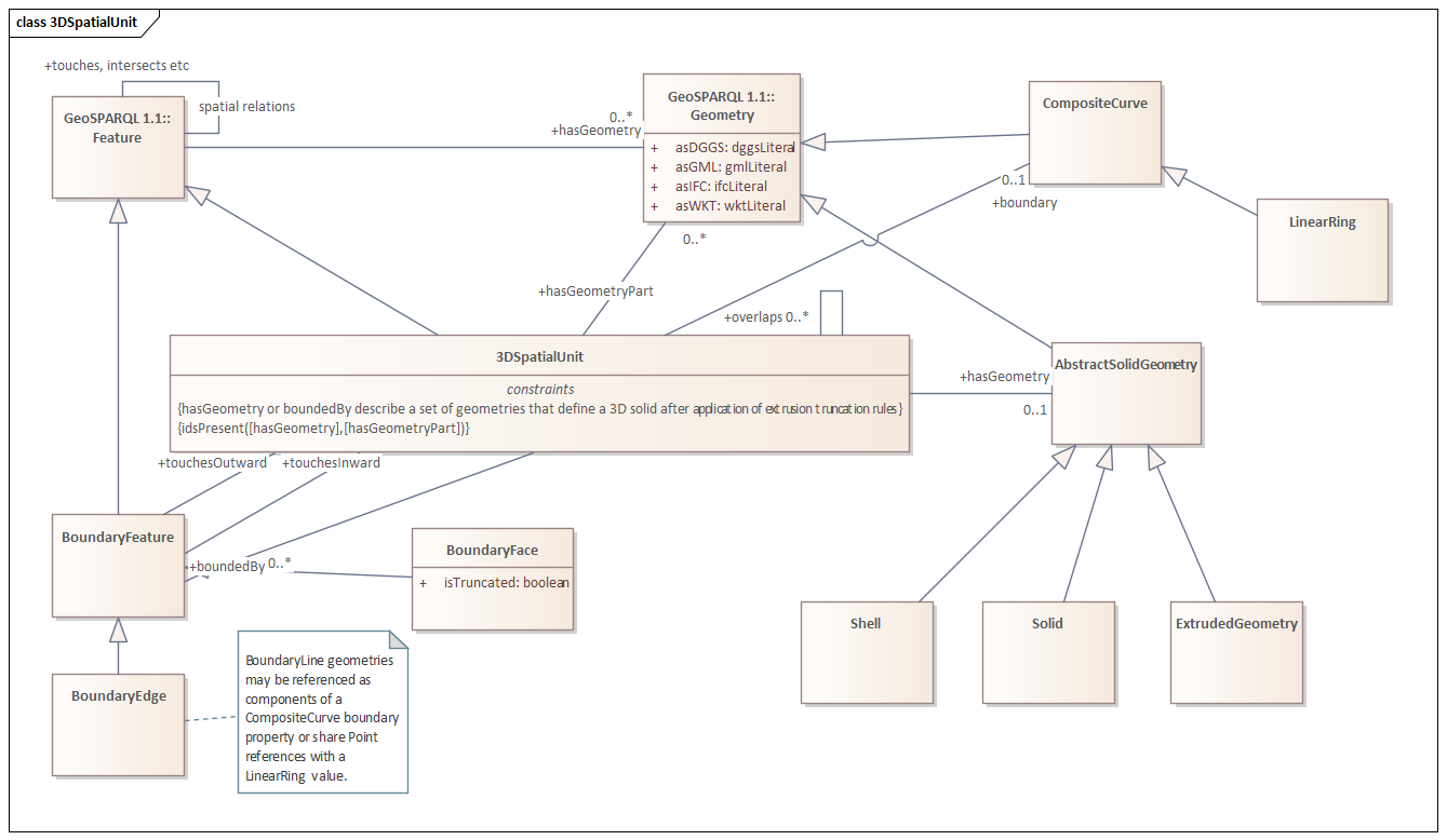
Abstract Solid Geometry
IRI: https://linked.data.gov.au/def/csdm/geometry/AbstractSolidGeometry
Abstract superclass for the set of 3-Dimensional Geometric Primitives which may be used to define 3D geometries and calculate alternative representations of interior, face and topology of an object in 3D cartesian space.
Is defined by Geometry Primitives Model
Subclass of
Superclass of
Properties
| Property | Description | Constraints | ||
|---|---|---|---|---|
|
geo:asGML Sourced from class:
|
||||
Boundary Edge
IRI: https://linked.data.gov.au/def/csdm/geometry/BoundaryEdge
A Boundary Line is a feature whose geometry is a connected set of lines representing the common part of two polygons share this set of oriented lines. As a feature it can participate in topological relationships between features that may, or may not, have planar geometry representations, and observations about the nature of the boundary can be made. The inner and outer features may be swapped by inverting the orientation of the geometry primitive, thus a single orientable boundary line may be used to partially define boundaries of both touching features. An oriented linear ring geometry representation for the planar extend of a bounded feature may be calculated from the geometries of the set of boundary features, using the inward or outward topology to adjust orientation accoridingly.
Is defined by Geometry Primitives Model
Subclass of
Properties
| Property | Description | Constraints | ||
|---|---|---|---|---|
|
node from Sourced from class:
|
Expected class type Boundary Node Cardinality: [1] |
|||
|
node to Sourced from class:
|
equivalent to a GML directedNode with orientation "-" |
Expected class type Boundary Node Cardinality: [1] |
||
|
hasGeometry Sourced from class:
|
hasGeometry property inherited from geo:Feature |
Expected class type geo:Geometry |
||
Boundary Face
IRI: https://linked.data.gov.au/def/csdm/geometry/BoundaryFace
A Boundary Face is a feature whose geometry is the orientable (possibly composite) surface where two solids touch. As a feature it can participate in topological relationships between features that may, or may not, have solid geometry representations, and observations about the nature of the face can be made. The inner and outer features may be swapped by inverting the orientation of the geometry primitive, thus a single orientable boundary face may be used to define boundary faces of both touching features. The shell of a feature may be computed from the set of faces defining boundaries.
Is defined by Geometry Primitives Model
Subclass of
Properties
| Property | Description | Constraints | ||
|---|---|---|---|---|
|
hasGeometry Sourced from class:
|
hasGeometry property inherited from geo:Feature |
Expected class type geo:Geometry |
||
Examples
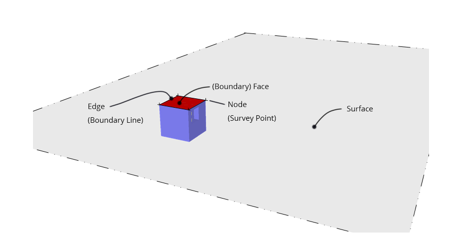
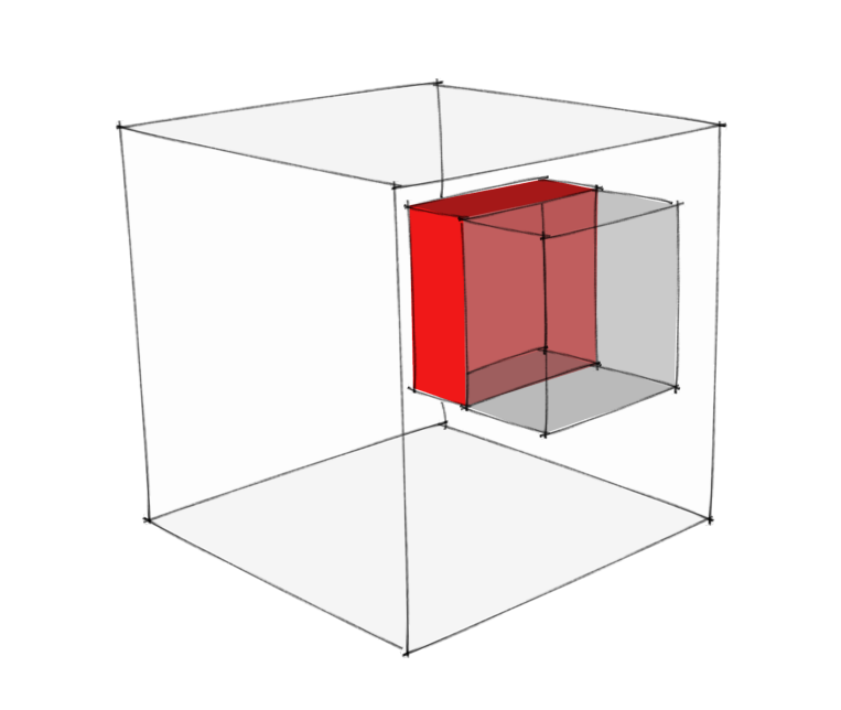
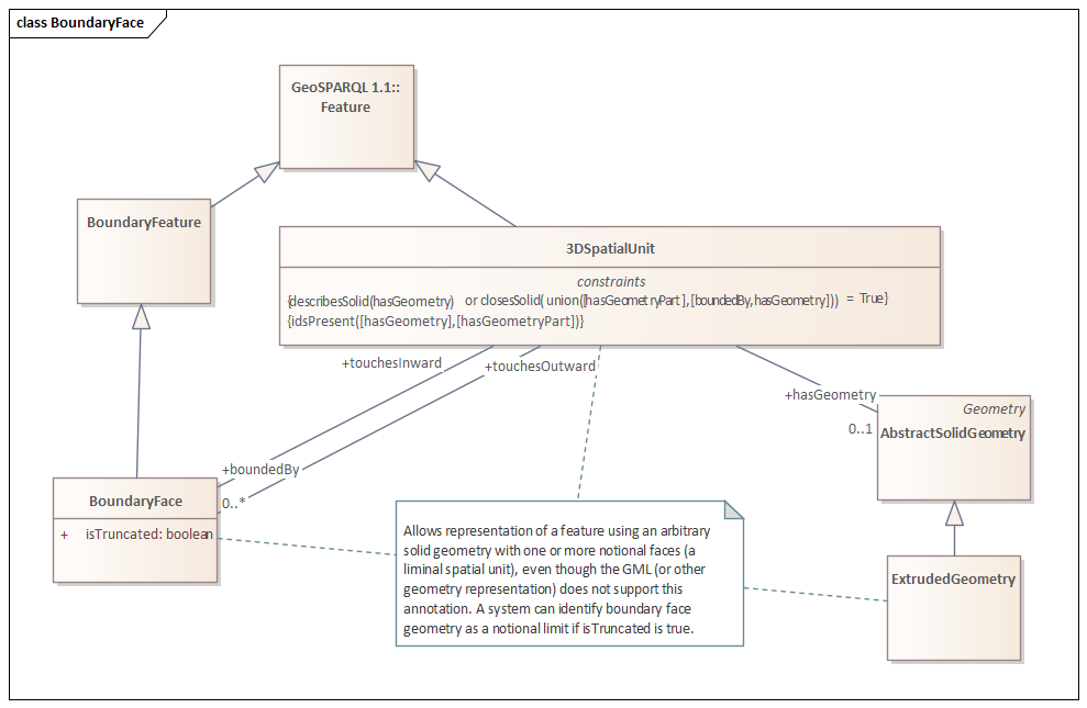
surveyobs_examples:blue_top_boundary
  a geometry:BoundaryFace ;
  geo:hasGeometry surveyobs_examples:blue_top ;
  geo:touchesInward examples:cp1 ;
  rdfs:label "blue_top boundary" ;
  skos:editorialNote "Example of a vertically unbounded boundary with a nominal solid geometry." ;
  geometry:isTruncated true ;
.
Boundary Feature
IRI: https://linked.data.gov.au/def/csdm/geometry/BoundaryFeature
A Boundary Feature is a topological concept - an object relates to a specific geometry type and adds information about the orientation of the geometry relative to topologically connected features. Note that a Featuredefined without specifiying the underlying geometry if required, allowing for example the geometry to be measured or calculated by operations on the geometries of related features.
Is defined by Geometry Primitives Model
Subclass of
Superclass of
Properties
| Property | Description | Constraints | ||
|---|---|---|---|---|
|
hasGeometry Sourced from class:
|
hasGeometry property inherited from geo:Feature |
Expected class type geo:Geometry |
||
Boundary Node
IRI: https://linked.data.gov.au/def/csdm/geometry/BoundaryNode
A Boundary Node is a feature whose geometry is a single Point representing the touching of two or more features at a single node. As a feature it can participate in topological relationships between features that may, or may not, have planar geometry representations.
|
Editorial Note
|
Statement required regarding the topology here - are we interest in the touching features or the edges of those features - those edges may not be separately represented so it should be the bounded features. If so - how does one identify the edges when building a topology? |
Is defined by Geometry Primitives Model
Subclass of
Properties
| Property | Description | Constraints | ||
|---|---|---|---|---|
|
hasGeometry Sourced from class:
|
hasGeometry property inherited from geo:Feature |
Expected class type geo:Geometry |
||
Annotation Properties
directed node
IRI: https://linked.data.gov.au/def/csdm/geometry/directedNode
is truncated (nominal boundary)
IRI: https://linked.data.gov.au/def/csdm/geometry/isTruncated
node to
IRI: https://linked.data.gov.au/def/csdm/geometry/nodeTo
equivalent to a GML directedNode with orientation "-"
Sub property of:
Datatype Properties
asGMLTopo
IRI: http://www.opengis.net/ont/geosparql#asGMLTopo
The GML serialization of topology
|
Scope Note
|
The Feature topology should be described using GML with references to the GML objects in the feature's hasGeometry property |
Sub property of:
Is defined by Geometry Primitives Model
extension
IRI: http://www.opengis.net/ont/geosparql#extension
The extension of an extruded geometry in the defined orientation, using the units of measure of the coordinate system of the base geometry.
isOutward
IRI: http://www.opengis.net/ont/geosparql#isOutward
true if orientation of extension is outward of oriented base geometry.
Object Properties
base surface
IRI: https://linked.data.gov.au/def/csdm/geometry/baseSurface
boundary
IRI: https://linked.data.gov.au/def/csdm/geometry/boundary
The boundary line for a surface footprint of a potentially 3D object. The surface is arbitrary and specific to the application domain.
Sub property of:
boundedBy
IRI: https://linked.data.gov.au/def/csdm/geometry/boundedBy
A Feature whose geometry forms part of the boundary of two other features bounded by a higher dimensional geometry.
extrusion
IRI: http://www.w3.org/2004/02/skos/core#extrusion
Description of extrusion requirements, typically a distance.
|
Editorial Note
|
A extrusion description may be limited to an orientation flag (isOutward) in which case local system rules may define the effective limit, if any. Alternatively a text description of specific requirements may be provided. Implementations may extend this with explit models of rules for extrusion. |
has geometry part
IRI: https://linked.data.gov.au/def/csdm/geometry/hasGeometryPart
A component of a Feature's geometry.
|
Scope Note
|
A component geometry part may particpate in the definition of other Features, such as shared boundary. |
Is defined by geo:
has topology
IRI: https://linked.data.gov.au/def/csdm/geometry/hasTopology
Representation of topological relationships to other features
Is defined by Geometry Primitives Model
solid member
IRI: https://linked.data.gov.au/def/csdm/geometry/solidMember
surface member
IRI: https://linked.data.gov.au/def/csdm/geometry/surfaceMember
touchesInward
IRI: http://www.opengis.net/ont/geosparql#touchesInward
the subject features touches the object feature in the inward direction relative to the orientation of the geometry specified by the subject features hasGeometry subject.
|
Editorial Note
|
Property chain axioms could be defined stating that if A hasGeometry G and A geo:touchesInward X and A geo:touchesOutward Y then X touches Y, X hasBoundary G, Y hasBoundary G. |
Sub property of:
touchesOutward
IRI: http://www.opengis.net/ont/geosparql#touchesOutward
the subject feature touches the object feature in the outward direction relative to the orientation of the subject feature hasGeometry subject.
Sub property of: